Shenzhen geodata
Shenzhen (Guangdong) is a seat of a second-order administrative division; located in China in Asia/Shanghai (GMT+8) time zone. With population of 10,358,381 people, there are 4 cities with bigger population in this country. Compared to other cities in China, 96.2% of cities are located further ↑North; 50.9% of cities are located further →East and 98.3% of cities have higher elevation than Shenzhen. Note1


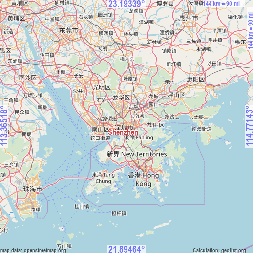
Shenzhen GPS coordinates[2]
22° 32' 43.944" North, 114° 4' 5.88" East
| Map corner | latitude | longitude |
|---|---|---|
| Upper-left | 23.19339°, | 113.36518° |
| Center: | 22.54554°, | 114.0683° |
| Lower-right: | 21.89464°, | 114.77143° |
| Map W x H: | 144.4×144.4 km | = 89.7×89.7mi |
| max Lat: | 53.31946° ⇑96.2% North |
| Shenzhen: | 22.54554° |
| min Lat: | ⇓3.8% South 18.22056° |
| min Long | Shenzhen | max Long |
| 75.07348° | 114.0683° | 134.28917° |
| W 49.1%⇐ | ⇒50.9% E |
Elevation
Elevation of Shenzhen is 4 m = 13 ft, and this is 480.8 m = 1577 ft below average elevation for this country.
| Max E: |
5622 m = 18445 ft | 98.3% |
| Avg. | 484.8 m = 1591 ft | |
| Shenzhen | 4 m = 13 ft | |
Min E: |
-3 m = -10 ft | 1.7% |
See also: Shenzhen elevation on elevation.city.
Geographical zone
Shenzhen is located in North Torrid zone (between Equator and Tropic of Cancer). Distance of this Northern Tropic circle is 99.1 km =61.6 mi to North.| Distance of | km | miles | from Shenzhen |
|---|---|---|---|
| North Pole | 7500.2 | 4660.4 | to North |
| Arctic Circle | 4894.3 | 3041.2 | to North |
| Tropic Cancer | 99.1 | 61.6 | to North |
| Equator | 2506.8 | 1557.7 | to South |


Nearby cities:
15 places around Shenzhen: (largest is in red/bold)
• Bantian
10.3 km =6.4 mi,  349°
349°
• Buji
7.2 km =4.5 mi,  27°
27°
• Dalang
15.9 km =9.9 mi,  337°
337°
• Haikuotiankong
13.3 km =8.3 mi,  261°
261°
• Haishan
14.8 km =9.2 mi,  84°
84°
• Liantang
10.6 km =6.6 mi, 77°
• Longhua
13.9 km =8.6 mi,  333°
333°
• Minzhi
9.3 km =5.8 mi, 340°
• Nanshan
13.3 km =8.3 mi,  266°
266°
• Nantou
15.7 km =9.8 mi, 265°
• Nanwan
8.7 km =5.4 mi,  47°
47°
• Shahe
9.2 km =5.7 mi, 274°
• Taoyuan
11.7 km =7.3 mi,  289°
289°
• Xili
13.2 km =8.2 mi, 290°
• Xin’an
15.9 km =9.9 mi,  280°
280°
Sources, notices
• [Note1] Compared only with cities in China existing in our database
• [Src1] Map data: © OpenStreetMap contributors (CC-BY-SA)
• [Src2] Other city data from geonames.org with taken over terms of usage.
• [Src3] Geographical zone / Annual Mean Temperature by Robert A. Rohde @ Wikipedia
