Dongzaogang geodata
Dongzaogang (Jiangsu) is a seat of a fourth-order administrative division; located in China in Asia/Shanghai (GMT+8) time zone. In our database, there are 1268 cities with bigger population. Compared to other cities in China, 61.7% of cities are located further ↓South; 90% of cities are located further ←West and 98.3% of cities have higher elevation than Dongzaogang. Note1


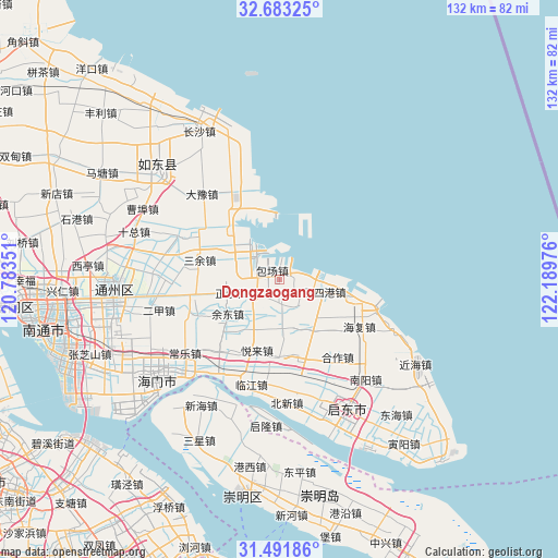
Dongzaogang GPS coordinates[2]
32° 5' 22.2" North, 121° 29' 11.868" East
| Map corner | latitude | longitude |
|---|---|---|
| Upper-left | 32.68325°, | 120.78351° |
| Center: | 32.0895°, | 121.48663° |
| Lower-right: | 31.49186°, | 122.18976° |
| Map W x H: | 132.5×132.5 km | = 82.3×82.3mi |
| max Lat: | 53.31946° ⇑38.3% North |
| Dongzaogang: | 32.0895° |
| min Lat: | ⇓61.7% South 18.22056° |
| min Long | Dongzaogang | max Long |
| 75.07348° | 121.48663° | 134.28917° |
| W 90%⇐ | ⇒10% E |
Elevation
Elevation of Dongzaogang is 4 m = 13 ft, and this is 480.8 m = 1577 ft below average elevation for this country.
| Max E: |
5622 m = 18445 ft | 98.3% |
| Avg. | 484.8 m = 1591 ft | |
| Dongzaogang | 4 m = 13 ft | |
Min E: |
-3 m = -10 ft | 1.7% |
See also: China elevation on elevation.city.
Geographical zone
Dongzaogang is located in North temperate zone (between Tropic of Cancer and the Arctic Circle). Distance of this Northern Tropic circle is 962.1 km =597.8 mi to South.| Distance of | km | miles | from Dongzaogang |
|---|---|---|---|
| North Pole | 6439 | 4001 | to North |
| Arctic Circle | 3833.2 | 2381.8 | to North |
| Tropic Cancer | 962.1 | 597.8 | to South |
| Equator | 3568 | 2217.1 | to South |


Nearby cities:
15 places around Dongzaogang: (largest is in red/bold)
• Antou
16.3 km =10.1 mi,  258°
258°
• Baochang
7.5 km =4.7 mi,  242°
242°
• Haifeng
12.9 km =8 mi,  310°
310°
• Juxing
14.7 km =9.1 mi,  158°
158°
• Liuhao
3.5 km =2.2 mi,  181°
181°
• Lüsigang
10.9 km =6.8 mi,  110°
110°
• Sanjia
17.3 km =10.7 mi,  104°
104°
• Shuhe
16.2 km =10.1 mi,  131°
131°
• Tianfen
6 km =3.7 mi,  119°
119°
• Tongxing
10.8 km =6.7 mi,  139°
139°
• Xiasanhe
13.5 km =8.4 mi,  208°
208°
• Xinhe
17.7 km =11 mi,  228°
228°
• Yudong
14.2 km =8.8 mi, 240°
• Zhaomin
12.8 km =8 mi, 132°
• Zhengyu
12.1 km =7.5 mi, 256°
Sources, notices
• [Note1] Compared only with cities in China existing in our database
• [Src1] Map data: © OpenStreetMap contributors (CC-BY-SA)
• [Src2] Other city data from geonames.org with taken over terms of usage.
• [Src3] Geographical zone / Annual Mean Temperature by Robert A. Rohde @ Wikipedia
