Zhengyu geodata
Zhengyu (Jiangsu) is a seat of a fourth-order administrative division; located in China in Asia/Shanghai (GMT+8) time zone. In our database, there are 1268 cities with bigger population. Compared to other cities in China, 61.6% of cities are located further ↓South; 89.4% of cities are located further ←West and 97.2% of cities have higher elevation than Zhengyu. Note1


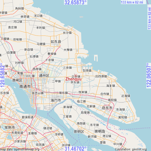
Zhengyu GPS coordinates[2]
32° 3' 53.352" North, 121° 21' 42.984" East
| Map corner | latitude | longitude |
|---|---|---|
| Upper-left | 32.65873°, | 120.65882° |
| Center: | 32.06482°, | 121.36194° |
| Lower-right: | 31.46702°, | 122.06507° |
| Map W x H: | 132.5×132.5 km | = 82.3×82.3mi |
| max Lat: | 53.31946° ⇑38.4% North |
| Zhengyu: | 32.06482° |
| min Lat: | ⇓61.6% South 18.22056° |
| min Long | Zhengyu | max Long |
| 75.07348° | 121.36194° | 134.28917° |
| W 89.4%⇐ | ⇒10.6% E |
Elevation
Elevation of Zhengyu is 5 m = 16 ft, and this is 479.8 m = 1574 ft below average elevation for this country.
| Max E: |
5622 m = 18445 ft | 97.2% |
| Avg. | 484.8 m = 1591 ft | |
| Zhengyu | 5 m = 16 ft | |
Min E: |
-3 m = -10 ft | 2.8% |
See also: China elevation on elevation.city.
Geographical zone
Zhengyu is located in North temperate zone (between Tropic of Cancer and the Arctic Circle). Distance of this Northern Tropic circle is 959.4 km =596.1 mi to South.| Distance of | km | miles | from Zhengyu |
|---|---|---|---|
| North Pole | 6441.8 | 4002.7 | to North |
| Arctic Circle | 3835.9 | 2383.5 | to North |
| Tropic Cancer | 959.4 | 596.1 | to South |
| Equator | 3565.3 | 2215.4 | to South |


Nearby cities:
15 places around Zhengyu: (largest is in red/bold)
• Antou
4.3 km =2.7 mi,  264°
264°
• Baochang
5.2 km =3.2 mi,  98°
98°
• Dongzaogang
12.1 km =7.5 mi,  76°
76°
• Erjia
17.3 km =10.7 mi,  254°
254°
• Haifeng
11.3 km =7 mi,  9°
9°
• Huolong
8.6 km =5.3 mi, 263°
• Liuhao
11.7 km =7.3 mi,  93°
93°
• Qilin
14.3 km =8.9 mi,  184°
184°
• Sanyu
10.1 km =6.3 mi,  315°
315°
• Sijia
9.9 km =6.2 mi,  235°
235°
• Tianfen
16.9 km =10.5 mi, 90°
• Xiasanhe
10.7 km =6.6 mi,  149°
149°
• Xinhe
9.1 km =5.7 mi,  188°
188°
• Yudong
4.2 km =2.6 mi, 188°
• Yuelai
15.8 km =9.8 mi,  155°
155°
Sources, notices
• [Note1] Compared only with cities in China existing in our database
• [Src1] Map data: © OpenStreetMap contributors (CC-BY-SA)
• [Src2] Other city data from geonames.org with taken over terms of usage.
• [Src3] Geographical zone / Annual Mean Temperature by Robert A. Rohde @ Wikipedia
