Fengling geodata
Fengling (Chongqing) is a seat of a fourth-order administrative division; located in China in Asia/Shanghai (GMT+8) time zone. In our database, there are 1268 cities with bigger population. Compared to other cities in China, 57.2% of cities are located further ↓South; 73.6% of cities are located further →East and 82.4% of cities have lower elevation than Fengling. Note1


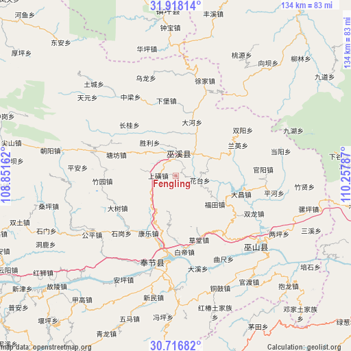
Fengling GPS coordinates[2]
31° 19' 9.84" North, 109° 33' 17.064" East
| Map corner | latitude | longitude |
|---|---|---|
| Upper-left | 31.91814°, | 108.85162° |
| Center: | 31.3194°, | 109.55474° |
| Lower-right: | 30.71682°, | 110.25787° |
| Map W x H: | 133.6×133.6 km | = 83×83mi |
| max Lat: | 53.31946° ⇑42.8% North |
| Fengling: | 31.3194° |
| min Lat: | ⇓57.2% South 18.22056° |
| min Long | Fengling | max Long |
| 75.07348° | 109.55474° | 134.28917° |
| W 26.4%⇐ | ⇒73.6% E |
Elevation
Elevation of Fengling is 811 m = 2661 ft, and this is 326.2 m = 1070 ft above average elevation for this country.
| Max E: |
5622 m = 18445 ft | 17.6% |
| Fengling | 811 m 2661 ft | |
| Avg. | 484.8 m = 1591 ft | |
Min E: |
-3 m = -10 ft | 82.4% |
See also: China elevation on elevation.city.
Geographical zone
Fengling is located in North temperate zone (between Tropic of Cancer and the Arctic Circle). Distance of this Northern Tropic circle is 876.5 km =544.6 mi to South.| Distance of | km | miles | from Fengling |
|---|---|---|---|
| North Pole | 6524.7 | 4054.3 | to North |
| Arctic Circle | 3918.8 | 2435 | to North |
| Tropic Cancer | 876.5 | 544.6 | to South |
| Equator | 3482.4 | 2163.9 | to South |


Nearby cities:
15 places around Fengling: (largest is in red/bold)
• Chengxiang
10.9 km =6.8 mi,  36°
36°
• Dadong
21.3 km =13.2 mi,  16°
16°
• Fenghuang
9.9 km =6.2 mi,  336°
336°
• Fenhe
20.5 km =12.7 mi,  188°
188°
• Futian
18.4 km =11.4 mi,  126°
126°
• Gulu
11 km =6.8 mi,  276°
276°
• Huatai
9.3 km =5.8 mi,  99°
99°
• Longxi
7.9 km =4.9 mi, 103°
• Ningchang
19.8 km =12.3 mi, 24°
• Pulian
2.1 km =1.3 mi,  165°
165°
• Shanghuang
6.7 km =4.2 mi,  271°
271°
• Shengli
16.3 km =10.1 mi,  321°
321°
• Tianxing
16.9 km =10.5 mi,  355°
355°
• Tongcheng
19.2 km =11.9 mi,  63°
63°
• Yanwan
14 km =8.7 mi, 189°
Sources, notices
• [Note1] Compared only with cities in China existing in our database
• [Src1] Map data: © OpenStreetMap contributors (CC-BY-SA)
• [Src2] Other city data from geonames.org with taken over terms of usage.
• [Src3] Geographical zone / Annual Mean Temperature by Robert A. Rohde @ Wikipedia
