Futian geodata
Futian (Chongqing) is a seat of a fourth-order administrative division; located in China in Asia/Shanghai (GMT+8) time zone. In our database, there are 1268 cities with bigger population. Compared to other cities in China, 56.4% of cities are located further ↓South; 72.7% of cities are located further →East and 64.2% of cities have lower elevation than Futian. Note1


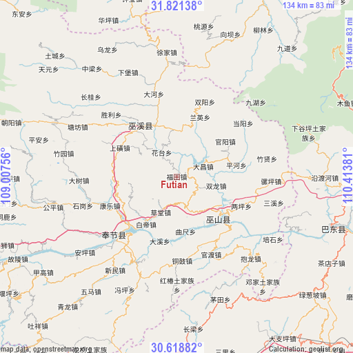
Futian GPS coordinates[2]
31° 13' 19.236" North, 109° 42' 38.448" East
| Map corner | latitude | longitude |
|---|---|---|
| Upper-left | 31.82138°, | 109.00756° |
| Center: | 31.22201°, | 109.71068° |
| Lower-right: | 30.61882°, | 110.41381° |
| Map W x H: | 133.7×133.7 km | = 83.1×83.1mi |
| max Lat: | 53.31946° ⇑43.6% North |
| Futian: | 31.22201° |
| min Lat: | ⇓56.4% South 18.22056° |
| min Long | Futian | max Long |
| 75.07348° | 109.71068° | 134.28917° |
| W 27.3%⇐ | ⇒72.7% E |
Elevation
Elevation of Futian is 313 m = 1027 ft, and this is 171.8 m = 564 ft below average elevation for this country.
| Max E: |
5622 m = 18445 ft | 35.8% |
| Avg. | 484.8 m = 1591 ft | |
| Futian | 313 m = 1027 ft | |
Min E: |
-3 m = -10 ft | 64.2% |
See also: China elevation on elevation.city.
Geographical zone
Futian is located in North temperate zone (between Tropic of Cancer and the Arctic Circle). Distance of this Northern Tropic circle is 865.6 km =537.9 mi to South.| Distance of | km | miles | from Futian |
|---|---|---|---|
| North Pole | 6535.5 | 4061 | to North |
| Arctic Circle | 3929.6 | 2441.7 | to North |
| Tropic Cancer | 865.6 | 537.9 | to South |
| Equator | 3471.6 | 2157.2 | to South |


Nearby cities:
15 places around Futian: (largest is in red/bold)
• Baidi
21.5 km =13.4 mi,  211°
211°
• Caotang
16.8 km =10.4 mi, 209°
• Chengxiang
21.3 km =13.2 mi,  336°
336°
• Dachang
10.1 km =6.3 mi,  59°
59°
• Fengling
18.4 km =11.4 mi,  306°
306°
• Fenhe
20.3 km =12.6 mi,  242°
242°
• Huatai
10.8 km =6.7 mi,  328°
328°
• Jinping
21.4 km =13.3 mi,  94°
94°
• Longxi
11.4 km =7.1 mi,  321°
321°
• Pulian
16.8 km =10.4 mi,  301°
301°
• Quchi
21 km =13 mi,  170°
170°
• Shuanglong
16.4 km =10.2 mi,  100°
100°
• Tongcheng
19.6 km =12.2 mi,  6°
6°
• Wushan
22.3 km =13.9 mi,  135°
135°
• Yanwan
17.4 km =10.8 mi,  260°
260°
Sources, notices
• [Note1] Compared only with cities in China existing in our database
• [Src1] Map data: © OpenStreetMap contributors (CC-BY-SA)
• [Src2] Other city data from geonames.org with taken over terms of usage.
• [Src3] Geographical zone / Annual Mean Temperature by Robert A. Rohde @ Wikipedia
