Fengmu geodata
Fengmu (Chongqing) is a seat of a fourth-order administrative division; located in China in Asia/Shanghai (GMT+8) time zone. In our database, there are 1268 cities with bigger population. Compared to other cities in China, 51.7% of cities are located further ↑North; 78.6% of cities are located further →East and 88% of cities have lower elevation than Fengmu. Note1


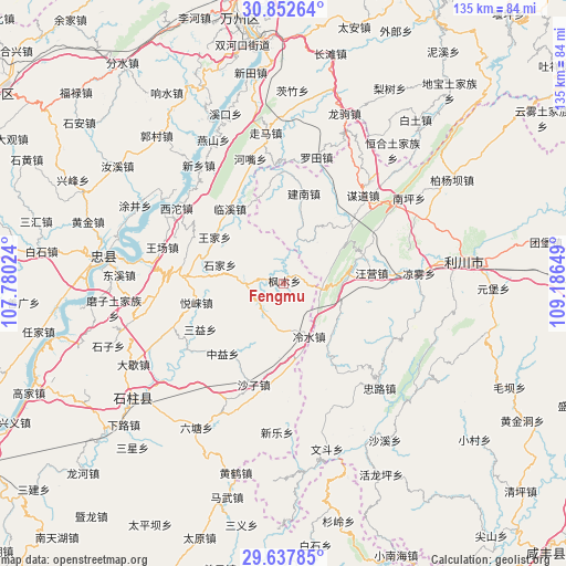
Fengmu GPS coordinates[2]
30° 14' 49.632" North, 108° 29' 0.096" East
| Map corner | latitude | longitude |
|---|---|---|
| Upper-left | 30.85264°, | 107.78024° |
| Center: | 30.24712°, | 108.48336° |
| Lower-right: | 29.63785°, | 109.18649° |
| Map W x H: | 135.1×135.1 km | = 83.9×83.9mi |
| max Lat: | 53.31946° ⇑51.7% North |
| Fengmu: | 30.24712° |
| min Lat: | ⇓48.3% South 18.22056° |
| min Long | Fengmu | max Long |
| 75.07348° | 108.48336° | 134.28917° |
| W 21.4%⇐ | ⇒78.6% E |
Elevation
Elevation of Fengmu is 1189 m = 3901 ft, and this is 704.2 m = 2310 ft above average elevation for this country.
| Max E: |
5622 m = 18445 ft | 12% |
| Fengmu | 1189 m 3901 ft | |
| Avg. | 484.8 m = 1591 ft | |
Min E: |
-3 m = -10 ft | 88% |
See also: China elevation on elevation.city.
Geographical zone
Fengmu is located in North temperate zone (between Tropic of Cancer and the Arctic Circle). Distance of this Northern Tropic circle is 757.2 km =470.5 mi to South.| Distance of | km | miles | from Fengmu |
|---|---|---|---|
| North Pole | 6643.9 | 4128.3 | to North |
| Arctic Circle | 4038 | 2509.1 | to North |
| Tropic Cancer | 757.2 | 470.5 | to South |
| Equator | 3363.2 | 2089.8 | to South |


Nearby cities:
15 places around Fengmu: (largest is in red/bold)
• Huangshui
9 km =5.6 mi,  268°
268°
• Jiannan
21.9 km =13.6 mi,  12°
12°
• Jinling
28.3 km =17.6 mi,  177°
177°
• Lengshui
14.4 km =8.9 mi,  155°
155°
• Linxi
21.8 km =13.5 mi,  324°
324°
• Moudao
28.1 km =17.5 mi,  41°
41°
• Qiaotou
26.5 km =16.5 mi,  234°
234°
• Sanyi
22.7 km =14.1 mi,  241°
241°
• Shazi
25.4 km =15.8 mi,  196°
196°
• Shijia
15.8 km =9.8 mi,  286°
286°
• Wangjia
19.8 km =12.3 mi,  303°
303°
• Wangying
20.4 km =12.7 mi,  82°
82°
• Yuchi
25 km =15.5 mi, 274°
• Yuelai
21.3 km =13.2 mi,  257°
257°
• Zhongyi
22.4 km =13.9 mi,  220°
220°
Sources, notices
• [Note1] Compared only with cities in China existing in our database
• [Src1] Map data: © OpenStreetMap contributors (CC-BY-SA)
• [Src2] Other city data from geonames.org with taken over terms of usage.
• [Src3] Geographical zone / Annual Mean Temperature by Robert A. Rohde @ Wikipedia
