Wanchao geodata
Wanchao (Chongqing) is a seat of a fourth-order administrative division; located in China in Asia/Shanghai (GMT+8) time zone. In our database, there are 1268 cities with bigger population. Compared to other cities in China, 52.1% of cities are located further ↑North; 80% of cities are located further →East and 76.1% of cities have lower elevation than Wanchao. Note1


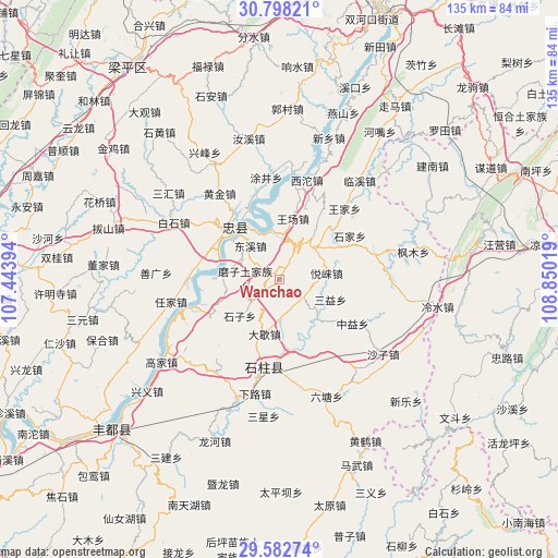
Wanchao GPS coordinates[2]
30° 11' 32.46" North, 108° 8' 49.416" East
| Map corner | latitude | longitude |
|---|---|---|
| Upper-left | 30.79821°, | 107.44394° |
| Center: | 30.19235°, | 108.14706° |
| Lower-right: | 29.58274°, | 108.85019° |
| Map W x H: | 135.1×135.1 km | = 83.9×83.9mi |
| max Lat: | 53.31946° ⇑52.1% North |
| Wanchao: | 30.19235° |
| min Lat: | ⇓47.9% South 18.22056° |
| min Long | Wanchao | max Long |
| 75.07348° | 108.14706° | 134.28917° |
| W 20%⇐ | ⇒80% E |
Elevation
Elevation of Wanchao is 549 m = 1801 ft, and this is 64.2 m = 211 ft above average elevation for this country.
| Max E: |
5622 m = 18445 ft | 23.9% |
| Wanchao | 549 m 1801 ft | |
| Avg. | 484.8 m = 1591 ft | |
Min E: |
-3 m = -10 ft | 76.1% |
See also: China elevation on elevation.city.
Geographical zone
Wanchao is located in North temperate zone (between Tropic of Cancer and the Arctic Circle). Distance of this Northern Tropic circle is 751.2 km =466.8 mi to South.| Distance of | km | miles | from Wanchao |
|---|---|---|---|
| North Pole | 6650 | 4132.1 | to North |
| Arctic Circle | 4044.1 | 2512.9 | to North |
| Tropic Cancer | 751.2 | 466.8 | to South |
| Equator | 3357.1 | 2086 | to South |


Nearby cities:
15 places around Wanchao: (largest is in red/bold)
• Daxie
13.7 km =8.5 mi,  194°
194°
• Dongxi
11.7 km =7.3 mi,  319°
319°
• Lichang
17.4 km =10.8 mi,  358°
358°
• Longsha
7.3 km =4.5 mi,  151°
151°
• Mozi
8.2 km =5.1 mi,  270°
270°
• Qiaotou
14.1 km =8.8 mi,  130°
130°
• Sanyi
13.4 km =8.3 mi,  111°
111°
• Shizi
12.9 km =8 mi,  226°
226°
• Wangchang
15.1 km =9.4 mi,  12°
12°
• Wuyang
14.4 km =8.9 mi,  275°
275°
• Xinsheng
19.4 km =12.1 mi, 275°
• Yanxi
11.8 km =7.3 mi,  350°
350°
• Yuchi
11 km =6.8 mi,  41°
41°
• Yuelai
11.6 km =7.2 mi,  82°
82°
• Zhongzhou
15.7 km =9.8 mi, 315°
Sources, notices
• [Note1] Compared only with cities in China existing in our database
• [Src1] Map data: © OpenStreetMap contributors (CC-BY-SA)
• [Src2] Other city data from geonames.org with taken over terms of usage.
• [Src3] Geographical zone / Annual Mean Temperature by Robert A. Rohde @ Wikipedia
