Huatian geodata
Huatian (Chongqing) is a seat of a fourth-order administrative division; located in China in Asia/Shanghai (GMT+8) time zone. In our database, there are 1268 cities with bigger population. Compared to other cities in China, 65.9% of cities are located further ↑North; 77.6% of cities are located further →East and 80.7% of cities have lower elevation than Huatian. Note1


Huatian GPS coordinates[2]
28° 57' 13.788" North, 108° 42' 16.452" East
| Map corner | latitude | longitude |
|---|---|---|
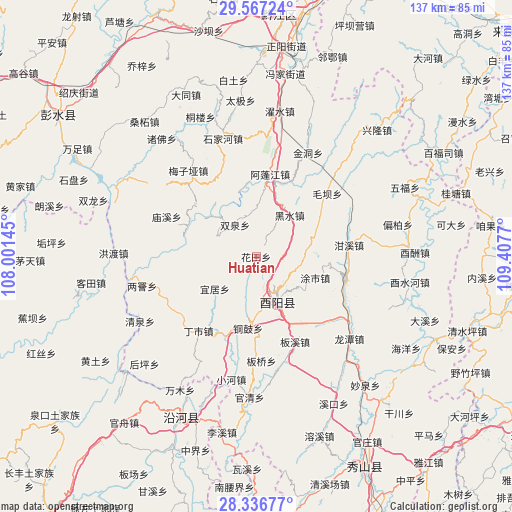
| Upper-left | 29.56724°, | 108.00145° |
| Center: | 28.95383°, | 108.70457° |
| Lower-right: | 28.33677°, | 109.4077° |
| Map W x H: | 136.8×136.8 km | = 85×85mi |
| max Lat: | 53.31946° ⇑65.9% North |
| Huatian: | 28.95383° |
| min Lat: | ⇓34.1% South 18.22056° |
| min Long | Huatian | max Long |
| 75.07348° | 108.70457° | 134.28917° |
| W 22.4%⇐ | ⇒77.6% E |
Elevation
Elevation of Huatian is 728 m = 2388 ft, and this is 243.2 m = 798 ft above average elevation for this country.
| Max E: |
5622 m = 18445 ft | 19.3% |
| Huatian | 728 m 2388 ft | |
| Avg. | 484.8 m = 1591 ft | |
Min E: |
-3 m = -10 ft | 80.7% |
See also: China elevation on elevation.city.
Geographical zone
Huatian is located in North temperate zone (between Tropic of Cancer and the Arctic Circle). Distance of this Northern Tropic circle is 613.4 km =381.1 mi to South.| Distance of | km | miles | from Huatian |
|---|---|---|---|
| North Pole | 6787.7 | 4217.7 | to North |
| Arctic Circle | 4181.8 | 2598.4 | to North |
| Tropic Cancer | 613.4 | 381.1 | to South |
| Equator | 3219.4 | 2000.4 | to South |


Nearby cities:
15 places around Huatian: (largest is in red/bold)
• Apengjiang
22.3 km =13.9 mi,  9°
9°
• Cangling
11.5 km =7.1 mi,  297°
297°
• Dingshi
25.1 km =15.6 mi,  217°
217°
• Echi
23.3 km =14.5 mi,  331°
331°
• Ganxi
25 km =15.5 mi,  83°
83°
• Heishui
14.4 km =8.9 mi,  38°
38°
• Langping
20.9 km =13 mi,  312°
312°
• Maoba
25.4 km =15.8 mi,  48°
48°
• Mawang
24.9 km =15.5 mi,  105°
105°
• Shuangquan
10.2 km =6.3 mi, 326°
• Tonggu
19.3 km =12 mi,  186°
186°
• Tushi
16.3 km =10.1 mi,  104°
104°
• Yiju
14 km =8.7 mi,  232°
232°
• Yudi
21.2 km =13.2 mi, 75°
• Zhongduo
13.3 km =8.3 mi,  154°
154°
Sources, notices
• [Note1] Compared only with cities in China existing in our database
• [Src1] Map data: © OpenStreetMap contributors (CC-BY-SA)
• [Src2] Other city data from geonames.org with taken over terms of usage.
• [Src3] Geographical zone / Annual Mean Temperature by Robert A. Rohde @ Wikipedia
