Zhufo geodata
Zhufo (Chongqing) is a seat of a fourth-order administrative division; located in China in Asia/Shanghai (GMT+8) time zone. In our database, there are 1268 cities with bigger population. Compared to other cities in China, 63% of cities are located further ↑North; 78.6% of cities are located further →East and 76.1% of cities have lower elevation than Zhufo. Note1


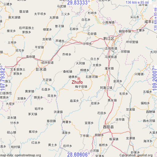
Zhufo GPS coordinates[2]
29° 13' 17.508" North, 108° 29' 48.984" East
| Map corner | latitude | longitude |
|---|---|---|
| Upper-left | 29.83333°, | 107.79382° |
| Center: | 29.22153°, | 108.49694° |
| Lower-right: | 28.60606°, | 109.20007° |
| Map W x H: | 136.5×136.5 km | = 84.8×84.8mi |
| max Lat: | 53.31946° ⇑63% North |
| Zhufo: | 29.22153° |
| min Lat: | ⇓37% South 18.22056° |
| min Long | Zhufo | max Long |
| 75.07348° | 108.49694° | 134.28917° |
| W 21.4%⇐ | ⇒78.6% E |
Elevation
Elevation of Zhufo is 550 m = 1804 ft, and this is 65.2 m = 214 ft above average elevation for this country.
| Max E: |
5622 m = 18445 ft | 23.9% |
| Zhufo | 550 m 1804 ft | |
| Avg. | 484.8 m = 1591 ft | |
Min E: |
-3 m = -10 ft | 76.1% |
See also: China elevation on elevation.city.
Geographical zone
Zhufo is located in North temperate zone (between Tropic of Cancer and the Arctic Circle). Distance of this Northern Tropic circle is 643.2 km =399.7 mi to South.| Distance of | km | miles | from Zhufo |
|---|---|---|---|
| North Pole | 6757.9 | 4199.2 | to North |
| Arctic Circle | 4152 | 2579.9 | to North |
| Tropic Cancer | 643.2 | 399.7 | to South |
| Equator | 3249.1 | 2018.9 | to South |


Nearby cities:
15 places around Zhufo: (largest is in red/bold)
• Anzi
10.7 km =6.6 mi,  193°
193°
• Baitu
22.5 km =14 mi,  38°
38°
• Daji
20 km =12.4 mi,  53°
53°
• Echi
13 km =8.1 mi,  135°
135°
• Langping
16.3 km =10.1 mi,  163°
163°
• Meiziya
7.1 km =4.4 mi, 162°
• Miaoxi
19.4 km =12.1 mi, 190°
• Sangzhe
11.5 km =7.1 mi,  303°
303°
• Shangan
20.7 km =12.9 mi,  221°
221°
• Shijia
11.3 km =7 mi,  81°
81°
• Shuishi
19.7 km =12.2 mi, 82°
• Tonglou
9.3 km =5.8 mi, 35°
• Xiaochang
13.6 km =8.5 mi,  6°
6°
• Xinhua
15.4 km =9.6 mi, 42°
• Xintian
22.2 km =13.8 mi,  262°
262°
Sources, notices
• [Note1] Compared only with cities in China existing in our database
• [Src1] Map data: © OpenStreetMap contributors (CC-BY-SA)
• [Src2] Other city data from geonames.org with taken over terms of usage.
• [Src3] Geographical zone / Annual Mean Temperature by Robert A. Rohde @ Wikipedia
