Shijia geodata
Shijia (Chongqing) is a seat of a fourth-order administrative division; located in China in Asia/Shanghai (GMT+8) time zone. In our database, there are 1268 cities with bigger population. Compared to other cities in China, 62.8% of cities are located further ↑North; 78.1% of cities are located further →East and 79.4% of cities have lower elevation than Shijia. Note1


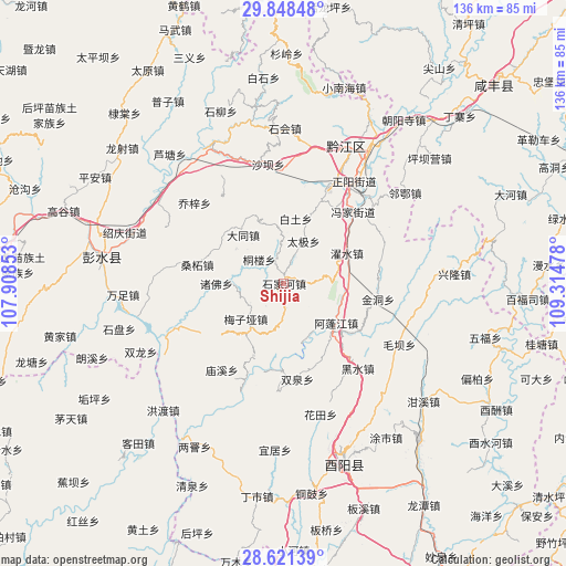
Shijia GPS coordinates[2]
29° 14' 12.372" North, 108° 36' 41.94" East
| Map corner | latitude | longitude |
|---|---|---|
| Upper-left | 29.84848°, | 107.90853° |
| Center: | 29.23677°, | 108.61165° |
| Lower-right: | 28.62139°, | 109.31478° |
| Map W x H: | 136.4×136.4 km | = 84.8×84.8mi |
| max Lat: | 53.31946° ⇑62.8% North |
| Shijia: | 29.23677° |
| min Lat: | ⇓37.2% South 18.22056° |
| min Long | Shijia | max Long |
| 75.07348° | 108.61165° | 134.28917° |
| W 21.9%⇐ | ⇒78.1% E |
Elevation
Elevation of Shijia is 668 m = 2192 ft, and this is 183.2 m = 601 ft above average elevation for this country.
| Max E: |
5622 m = 18445 ft | 20.6% |
| Shijia | 668 m 2192 ft | |
| Avg. | 484.8 m = 1591 ft | |
Min E: |
-3 m = -10 ft | 79.4% |
See also: China elevation on elevation.city.
Geographical zone
Shijia is located in North temperate zone (between Tropic of Cancer and the Arctic Circle). Distance of this Northern Tropic circle is 644.9 km =400.7 mi to South.| Distance of | km | miles | from Shijia |
|---|---|---|---|
| North Pole | 6756.2 | 4198.1 | to North |
| Arctic Circle | 4150.3 | 2578.9 | to North |
| Tropic Cancer | 644.9 | 400.7 | to South |
| Equator | 3250.8 | 2020 | to South |


Nearby cities:
15 places around Shijia: (largest is in red/bold)
• Anzi
18.3 km =11.4 mi,  228°
228°
• Apengjiang
15.8 km =9.8 mi,  126°
126°
• Baitu
16.1 km =10 mi,  10°
10°
• Daji
11.4 km =7.1 mi,  25°
25°
• Echi
11.2 km =7 mi,  190°
190°
• Jinxi
18.8 km =11.7 mi,  22°
22°
• Langping
18.5 km =11.5 mi,  200°
200°
• Meiziya
12.4 km =7.7 mi, 226°
• Sangzhe
21.2 km =13.2 mi,  282°
282°
• Shuishi
8.5 km =5.3 mi,  84°
84°
• Tonglou
8.2 km =5.1 mi,  315°
315°
• Xiaochang
15.2 km =9.4 mi, 320°
• Xinhua
9.7 km =6 mi,  355°
355°
• Zhufo
11.3 km =7 mi,  261°
261°
• Zhuoshui
17.1 km =10.6 mi,  64°
64°
Sources, notices
• [Note1] Compared only with cities in China existing in our database
• [Src1] Map data: © OpenStreetMap contributors (CC-BY-SA)
• [Src2] Other city data from geonames.org with taken over terms of usage.
• [Src3] Geographical zone / Annual Mean Temperature by Robert A. Rohde @ Wikipedia
