Dongyang geodata
Dongyang (Chongqing) is a seat of a fourth-order administrative division; located in China in Asia/Shanghai (GMT+8) time zone. In our database, there are 1268 cities with bigger population. Compared to other cities in China, 56% of cities are located further ↑North; 85.3% of cities are located further →East and 55.6% of cities have lower elevation than Dongyang. Note1


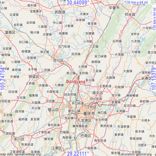
Dongyang GPS coordinates[2]
29° 49' 58.476" North, 106° 27' 2.376" East
| Map corner | latitude | longitude |
|---|---|---|
| Upper-left | 30.44099°, | 105.74754° |
| Center: | 29.83291°, | 106.45066° |
| Lower-right: | 29.22111°, | 107.15379° |
| Map W x H: | 135.6×135.6 km | = 84.3×84.3mi |
| max Lat: | 53.31946° ⇑56% North |
| Dongyang: | 29.83291° |
| min Lat: | ⇓44% South 18.22056° |
| min Long | Dongyang | max Long |
| 75.07348° | 106.45066° | 134.28917° |
| W 14.7%⇐ | ⇒85.3% E |
Elevation
Elevation of Dongyang is 212 m = 696 ft, and this is 272.8 m = 895 ft below average elevation for this country.
| Max E: |
5622 m = 18445 ft | 44.4% |
| Avg. | 484.8 m = 1591 ft | |
| Dongyang | 212 m = 696 ft | |
Min E: |
-3 m = -10 ft | 55.6% |
See also: China elevation on elevation.city.
Geographical zone
Dongyang is located in North temperate zone (between Tropic of Cancer and the Arctic Circle). Distance of this Northern Tropic circle is 711.2 km =441.9 mi to South.| Distance of | km | miles | from Dongyang |
|---|---|---|---|
| North Pole | 6690 | 4157 | to North |
| Arctic Circle | 4084.1 | 2537.7 | to North |
| Tropic Cancer | 711.2 | 441.9 | to South |
| Equator | 3317.1 | 2061.1 | to South |


Nearby cities:
15 places around Dongyang: (largest is in red/bold)
• Batang
15.2 km =9.4 mi,  271°
271°
• Beibei
1.5 km =0.9 mi,  245°
245°
• Beiwenquan
3 km =1.9 mi, 271°
• Caijiagang
10.3 km =6.4 mi,  166°
166°
• Chaoyang
1 km =0.6 mi,  255°
255°
• Chengjiang
7.7 km =4.8 mi,  304°
304°
• Fuxing
10.4 km =6.5 mi,  98°
98°
• Jingguan
12.9 km =8 mi,  57°
57°
• Longfeng
2.9 km =1.8 mi,  226°
226°
• Shijialiang
5.4 km =3.4 mi,  157°
157°
• Shuitu
7.2 km =4.5 mi,  141°
141°
• Tianfu
6.5 km =4 mi,  45°
45°
• Tuchang
11 km =6.8 mi,  20°
20°
• Xiema
10.3 km =6.4 mi, 230°
• Yanjing
15.8 km =9.8 mi,  322°
322°
Sources, notices
• [Note1] Compared only with cities in China existing in our database
• [Src1] Map data: © OpenStreetMap contributors (CC-BY-SA)
• [Src2] Other city data from geonames.org with taken over terms of usage.
• [Src3] Geographical zone / Annual Mean Temperature by Robert A. Rohde @ Wikipedia
