Jingguan geodata
Jingguan (Chongqing) is a seat of a fourth-order administrative division; located in China in Asia/Shanghai (GMT+8) time zone. In our database, there are 1268 cities with bigger population. Compared to other cities in China, 55.2% of cities are located further ↑North; 84.9% of cities are located further →East and 68.7% of cities have lower elevation than Jingguan. Note1


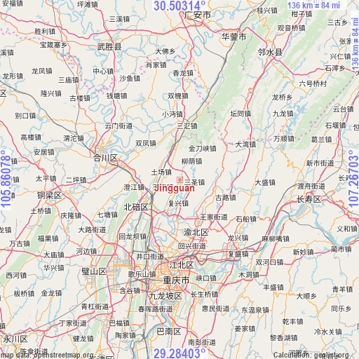
Jingguan GPS coordinates[2]
29° 53' 43.62" North, 106° 33' 50.04" East
| Map corner | latitude | longitude |
|---|---|---|
| Upper-left | 30.50314°, | 105.86078° |
| Center: | 29.89545°, | 106.5639° |
| Lower-right: | 29.28403°, | 107.26703° |
| Map W x H: | 135.6×135.6 km | = 84.3×84.3mi |
| max Lat: | 53.31946° ⇑55.2% North |
| Jingguan: | 29.89545° |
| min Lat: | ⇓44.8% South 18.22056° |
| min Long | Jingguan | max Long |
| 75.07348° | 106.5639° | 134.28917° |
| W 15.1%⇐ | ⇒84.9% E |
Elevation
Elevation of Jingguan is 389 m = 1276 ft, and this is 95.8 m = 314 ft below average elevation for this country.
| Max E: |
5622 m = 18445 ft | 31.3% |
| Avg. | 484.8 m = 1591 ft | |
| Jingguan | 389 m = 1276 ft | |
Min E: |
-3 m = -10 ft | 68.7% |
See also: China elevation on elevation.city.
Geographical zone
Jingguan is located in North temperate zone (between Tropic of Cancer and the Arctic Circle). Distance of this Northern Tropic circle is 718.1 km =446.2 mi to South.| Distance of | km | miles | from Jingguan |
|---|---|---|---|
| North Pole | 6683 | 4152.6 | to North |
| Arctic Circle | 4077.1 | 2533.4 | to North |
| Tropic Cancer | 718.1 | 446.2 | to South |
| Equator | 3324.1 | 2065.5 | to South |


Nearby cities:
15 places around Jingguan: (largest is in red/bold)
• Beibei
14.4 km =8.9 mi,  238°
238°
• Beiwenquan
15.5 km =9.6 mi, 243°
• Chaoyang
13.9 km =8.6 mi, 238°
• Dongyang
12.9 km =8 mi, 237°
• Fuxing
8.5 km =5.3 mi,  184°
184°
• Jindaoxia
14.9 km =9.3 mi,  34°
34°
• Liuyin
8.6 km =5.3 mi, 30°
• Longfeng
15.8 km =9.8 mi, 235°
• Mu’er
12.6 km =7.8 mi,  142°
142°
• Qingping
10 km =6.2 mi,  335°
335°
• Shijialiang
14.9 km =9.3 mi,  216°
216°
• Shuitu
14.1 km =8.8 mi,  206°
206°
• Tianfu
6.8 km =4.2 mi,  249°
249°
• Tuchang
7.8 km =4.8 mi,  295°
295°
• Xinglong
13.7 km =8.5 mi,  92°
92°
Sources, notices
• [Note1] Compared only with cities in China existing in our database
• [Src1] Map data: © OpenStreetMap contributors (CC-BY-SA)
• [Src2] Other city data from geonames.org with taken over terms of usage.
• [Src3] Geographical zone / Annual Mean Temperature by Robert A. Rohde @ Wikipedia
