Kezileboyi geodata
Kezileboyi (Xinjiang) is a seat of a fourth-order administrative division; located in China in Asia/Urumqi (GMT+6) time zone. In our database, there are 1268 cities with bigger population. Compared to other cities in China, 84.3% of cities are located further ↓South; 99.9% of cities are located further →East and 88.5% of cities have lower elevation than Kezileboyi. Note1


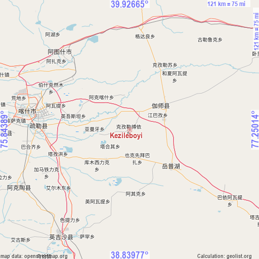
Kezileboyi GPS coordinates[2]
39° 23' 7.188" North, 76° 32' 49.236" East
| Map corner | latitude | longitude |
|---|---|---|
| Upper-left | 39.92665°, | 75.84389° |
| Center: | 39.38533°, | 76.54701° |
| Lower-right: | 38.83977°, | 77.25014° |
| Map W x H: | 120.8×120.8 km | = 75.1×75.1mi |
| max Lat: | 53.31946° ⇑15.7% North |
| Kezileboyi: | 39.38533° |
| min Lat: | ⇓84.3% South 18.22056° |
| min Long | Kezileboyi | max Long |
| 75.07348° | 76.54701° | 134.28917° |
| W 0.1%⇐ | ⇒99.9% E |
Elevation
Elevation of Kezileboyi is 1230 m = 4035 ft, and this is 745.2 m = 2445 ft above average elevation for this country.
| Max E: |
5622 m = 18445 ft | 11.5% |
| Kezileboyi | 1230 m 4035 ft | |
| Avg. | 484.8 m = 1591 ft | |
Min E: |
-3 m = -10 ft | 88.5% |
See also: China elevation on elevation.city.
Geographical zone
Kezileboyi is located in North temperate zone (between Tropic of Cancer and the Arctic Circle). Distance of this Northern Tropic circle is 1773.3 km =1101.9 mi to South.| Distance of | km | miles | from Kezileboyi |
|---|---|---|---|
| North Pole | 5627.8 | 3497 | to North |
| Arctic Circle | 3021.9 | 1877.7 | to North |
| Tropic Cancer | 1773.3 | 1101.9 | to South |
| Equator | 4379.2 | 2721.1 | to South |


Nearby cities:
15 places around Kezileboyi: (largest is in red/bold)
• Aiximan
12.3 km =7.6 mi,  192°
192°
• Aqqik
28.9 km =18 mi,  175°
175°
• Gedaliang
43.6 km =27.1 mi,  11°
11°
• Hexia’awati
33.4 km =20.8 mi,  38°
38°
• Jiangbazi
15.1 km =9.4 mi,  62°
62°
• Jiashi
20.8 km =12.9 mi,  53°
53°
• Kizilsu
36.2 km =22.5 mi,  27°
27°
• Seyeke
21.7 km =13.5 mi,  152°
152°
• Shule
42.7 km =26.5 mi,  272°
272°
• Tieremu
47.8 km =29.7 mi,  126°
126°
• Tierimu
21.2 km =13.2 mi, 48°
• Xiaputule
11 km =6.8 mi, 33°
• Yekexianbaibazha
12.8 km =8 mi,  165°
165°
• Yingmaili
25.9 km =16.1 mi, 57°
• Yopurga
24.8 km =15.4 mi, 130°
Sources, notices
• [Note1] Compared only with cities in China existing in our database
• [Src1] Map data: © OpenStreetMap contributors (CC-BY-SA)
• [Src2] Other city data from geonames.org with taken over terms of usage.
• [Src3] Geographical zone / Annual Mean Temperature by Robert A. Rohde @ Wikipedia
