Shule geodata
Shule (Xinjiang) is a seat of a third-order administrative division; located in China in Asia/Urumqi (GMT+6) time zone. In our database, there are 1268 cities with bigger population. Compared to other cities in China, 84.3% of cities are located further ↓South; 100% of cities are located further →East and 89% of cities have lower elevation than Shule. Note1


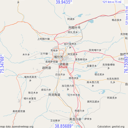
Shule GPS coordinates[2]
39° 24' 8.316" North, 76° 3' 2.88" East
| Map corner | latitude | longitude |
|---|---|---|
| Upper-left | 39.9435°, | 75.34768° |
| Center: | 39.40231°, | 76.0508° |
| Lower-right: | 38.85689°, | 76.75393° |
| Map W x H: | 120.8×120.8 km | = 75.1×75.1mi |
| max Lat: | 53.31946° ⇑15.7% North |
| Shule: | 39.40231° |
| min Lat: | ⇓84.3% South 18.22056° |
| min Long | Shule | max Long |
| 75.07348° | 76.0508° | 134.28917° |
| W 0%⇐ | ⇒100% E |
Elevation
Elevation of Shule is 1269 m = 4163 ft, and this is 784.2 m = 2573 ft above average elevation for this country.
| Max E: |
5622 m = 18445 ft | 11% |
| Shule | 1269 m 4163 ft | |
| Avg. | 484.8 m = 1591 ft | |
Min E: |
-3 m = -10 ft | 89% |
See also: China elevation on elevation.city.
Geographical zone
Shule is located in North temperate zone (between Tropic of Cancer and the Arctic Circle). Distance of this Northern Tropic circle is 1775.2 km =1103.1 mi to South.| Distance of | km | miles | from Shule |
|---|---|---|---|
| North Pole | 5625.9 | 3495.8 | to North |
| Arctic Circle | 3020 | 1876.5 | to North |
| Tropic Cancer | 1775.2 | 1103.1 | to South |
| Equator | 4381.1 | 2722.3 | to South |


Nearby cities:
15 places around Shule: (largest is in red/bold)
• Aiximan
42.3 km =26.3 mi,  109°
109°
• Aqqik
54.5 km =33.9 mi,  124°
124°
• Arzak
31 km =19.3 mi,  11°
11°
• Chengguan
55.2 km =34.3 mi,  169°
169°
• Jiangbazi
56.2 km =34.9 mi,  84°
84°
• Kashgar
9.2 km =5.7 mi,  325°
325°
• Kezileboyi
42.7 km =26.5 mi,  92°
92°
• Longfu
51.1 km =31.8 mi,  179°
179°
• Mangxing
54.5 km =33.9 mi, 166°
• Qiaoleipan
52.2 km =32.4 mi, 173°
• Saxin
56.4 km =35 mi,  156°
156°
• Seyeke
56.9 km =35.4 mi, 111°
• Xiaputule
49.2 km =30.6 mi, 81°
• Yekexianbaibazha
48.1 km =29.9 mi, 107°
• Yingye’er
52 km =32.3 mi, 156°
Sources, notices
• [Note1] Compared only with cities in China existing in our database
• [Src1] Map data: © OpenStreetMap contributors (CC-BY-SA)
• [Src2] Other city data from geonames.org with taken over terms of usage.
• [Src3] Geographical zone / Annual Mean Temperature by Robert A. Rohde @ Wikipedia
