Xijiang geodata
Xijiang (Hubei) is a seat of a fourth-order administrative division; located in China in Asia/Shanghai (GMT+8) time zone. In our database, there are 1268 cities with bigger population. Compared to other cities in China, 50.2% of cities are located further ↓South; 53.2% of cities are located further →East and 79.8% of cities have higher elevation than Xijiang. Note1


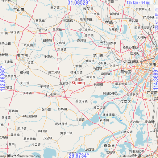
Xijiang GPS coordinates[2]
30° 28' 52.428" North, 113° 40' 0.372" East
| Map corner | latitude | longitude |
|---|---|---|
| Upper-left | 31.08529°, | 112.96365° |
| Center: | 30.48123°, | 113.66677° |
| Lower-right: | 29.8734°, | 114.3699° |
| Map W x H: | 134.7×134.7 km | = 83.7×83.7mi |
| max Lat: | 53.31946° ⇑49.8% North |
| Xijiang: | 30.48123° |
| min Lat: | ⇓50.2% South 18.22056° |
| min Long | Xijiang | max Long |
| 75.07348° | 113.66677° | 134.28917° |
| W 46.8%⇐ | ⇒53.2% E |
Elevation
Elevation of Xijiang is 27 m = 89 ft, and this is 457.8 m = 1502 ft below average elevation for this country.
| Max E: |
5622 m = 18445 ft | 79.8% |
| Avg. | 484.8 m = 1591 ft | |
| Xijiang | 27 m = 89 ft | |
Min E: |
-3 m = -10 ft | 20.2% |
See also: China elevation on elevation.city.
Geographical zone
Xijiang is located in North temperate zone (between Tropic of Cancer and the Arctic Circle). Distance of this Northern Tropic circle is 783.3 km =486.7 mi to South.| Distance of | km | miles | from Xijiang |
|---|---|---|---|
| North Pole | 6617.9 | 4112.2 | to North |
| Arctic Circle | 4012 | 2492.9 | to North |
| Tropic Cancer | 783.3 | 486.7 | to South |
| Equator | 3389.2 | 2106 | to South |


Nearby cities:
15 places around Xijiang: (largest is in red/bold)
• Chenggong
9.7 km =6 mi,  150°
150°
• Chenghuang
18.1 km =11.2 mi,  30°
30°
• Chenhu
13.7 km =8.5 mi,  255°
255°
• Fenshui
11.5 km =7.1 mi,  351°
351°
• Huilong
15.2 km =9.4 mi,  281°
281°
• Litan
14.8 km =9.2 mi,  318°
318°
• Maiwang
7 km =4.3 mi, 284°
• Makou
18.6 km =11.6 mi,  58°
58°
• Miaotou
16.5 km =10.3 mi,  40°
40°
• Nanhe
10.3 km =6.4 mi,  82°
82°
• Wantan
11.2 km =7 mi,  5°
5°
• Xiaosi
20.9 km =13 mi, 150°
• Xiliuhe
19.2 km =11.9 mi,  173°
173°
• Yanglingou
6.4 km =4 mi,  337°
337°
• Zhuru
16.8 km =10.4 mi,  105°
105°
Sources, notices
• [Note1] Compared only with cities in China existing in our database
• [Src1] Map data: © OpenStreetMap contributors (CC-BY-SA)
• [Src2] Other city data from geonames.org with taken over terms of usage.
• [Src3] Geographical zone / Annual Mean Temperature by Robert A. Rohde @ Wikipedia
