Nanhe geodata
Nanhe (Hubei) is a seat of a fourth-order administrative division; located in China in Asia/Shanghai (GMT+8) time zone. In our database, there are 1268 cities with bigger population. Compared to other cities in China, 50.3% of cities are located further ↓South; 52.6% of cities are located further →East and 79.3% of cities have higher elevation than Nanhe. Note1


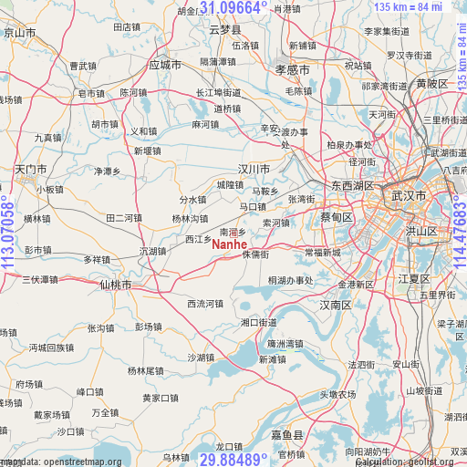
Nanhe GPS coordinates[2]
30° 29' 33.54" North, 113° 46' 25.32" East
| Map corner | latitude | longitude |
|---|---|---|
| Upper-left | 31.09664°, | 113.07058° |
| Center: | 30.49265°, | 113.7737° |
| Lower-right: | 29.88489°, | 114.47683° |
| Map W x H: | 134.7×134.7 km | = 83.7×83.7mi |
| max Lat: | 53.31946° ⇑49.7% North |
| Nanhe: | 30.49265° |
| min Lat: | ⇓50.3% South 18.22056° |
| min Long | Nanhe | max Long |
| 75.07348° | 113.7737° | 134.28917° |
| W 47.4%⇐ | ⇒52.6% E |
Elevation
Elevation of Nanhe is 28 m = 92 ft, and this is 456.8 m = 1499 ft below average elevation for this country.
| Max E: |
5622 m = 18445 ft | 79.3% |
| Avg. | 484.8 m = 1591 ft | |
| Nanhe | 28 m = 92 ft | |
Min E: |
-3 m = -10 ft | 20.7% |
See also: China elevation on elevation.city.
Geographical zone
Nanhe is located in North temperate zone (between Tropic of Cancer and the Arctic Circle). Distance of this Northern Tropic circle is 784.5 km =487.5 mi to South.| Distance of | km | miles | from Nanhe |
|---|---|---|---|
| North Pole | 6616.6 | 4111.4 | to North |
| Arctic Circle | 4010.7 | 2492.1 | to North |
| Tropic Cancer | 784.5 | 487.5 | to South |
| Equator | 3390.5 | 2106.8 | to South |


Nearby cities:
15 places around Nanhe: (largest is in red/bold)
• Chenggong
11.2 km =7 mi,  209°
209°
• Chenghuang
14.4 km =8.9 mi,  355°
355°
• Fenshui
15.6 km =9.7 mi,  310°
310°
• Hanchuan
17.5 km =10.9 mi, 357°
• Maiwang
17 km =10.6 mi,  271°
271°
• Makou
10.2 km =6.3 mi,  33°
33°
• Ma’an
15.4 km =9.6 mi,  35°
35°
• Miaotou
11.2 km =7 mi,  3°
3°
• Suohe
12.3 km =7.6 mi,  74°
74°
• Wantan
13.4 km =8.3 mi,  317°
317°
• Xiannüshan
17.5 km =10.9 mi,  17°
17°
• Xijiang
10.3 km =6.4 mi,  262°
262°
• Yanglingou
13.5 km =8.4 mi,  289°
289°
• Yong’an
15.2 km =9.4 mi,  103°
103°
• Zhuru
8.2 km =5.1 mi,  133°
133°
Sources, notices
• [Note1] Compared only with cities in China existing in our database
• [Src1] Map data: © OpenStreetMap contributors (CC-BY-SA)
• [Src2] Other city data from geonames.org with taken over terms of usage.
• [Src3] Geographical zone / Annual Mean Temperature by Robert A. Rohde @ Wikipedia
