Wancheng geodata
Wancheng (Guangdong) is a seat of a fourth-order administrative division; located in China in Asia/Shanghai (GMT+8) time zone. In our database, there are 1268 cities with bigger population. Compared to other cities in China, 94.2% of cities are located further ↑North; 52.8% of cities are located further →East and 86.9% of cities have higher elevation than Wancheng. Note1


Wancheng GPS coordinates[2]
23° 2' 56.544" North, 113° 45' 7.956" East
| Map corner | latitude | longitude |
|---|---|---|
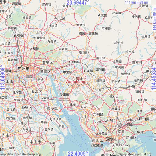
| Upper-left | 23.69447°, | 113.04909° |
| Center: | 23.04904°, | 113.75221° |
| Lower-right: | 22.4005°, | 114.45534° |
| Map W x H: | 143.9×143.9 km | = 89.4×89.4mi |
| max Lat: | 53.31946° ⇑94.2% North |
| Wancheng: | 23.04904° |
| min Lat: | ⇓5.8% South 18.22056° |
| min Long | Wancheng | max Long |
| 75.07348° | 113.75221° | 134.28917° |
| W 47.2%⇐ | ⇒52.8% E |
Elevation
Elevation of Wancheng is 13 m = 43 ft, and this is 471.8 m = 1548 ft below average elevation for this country.
| Max E: |
5622 m = 18445 ft | 86.9% |
| Avg. | 484.8 m = 1591 ft | |
| Wancheng | 13 m = 43 ft | |
Min E: |
-3 m = -10 ft | 13.1% |
See also: China elevation on elevation.city.
Geographical zone
Wancheng is located in North Torrid zone (between Equator and Tropic of Cancer). Distance of this Northern Tropic circle is 43.1 km =26.8 mi to North.| Distance of | km | miles | from Wancheng |
|---|---|---|---|
| North Pole | 7444.2 | 4625.6 | to North |
| Arctic Circle | 4838.4 | 3006.4 | to North |
| Tropic Cancer | 43.1 | 26.8 | to North |
| Equator | 2562.8 | 1592.4 | to South |


Nearby cities:
15 places around Wancheng: (largest is in red/bold)
• Chashan
12.2 km =7.6 mi,  79°
79°
• Daojiao
11 km =6.8 mi,  240°
240°
• Dongcheng
3.4 km =2.1 mi,  97°
97°
• Dongguan
3.5 km =2.2 mi,  186°
186°
• Gaobu
5.3 km =3.3 mi,  318°
318°
• Liaobu
14.3 km =8.9 mi,  112°
112°
• Nancheng
2.8 km =1.7 mi,  197°
197°
• Shazhuang
12.6 km =7.8 mi,  42°
42°
• Shijie
6.6 km =4.1 mi, 38°
• Shilong
12.1 km =7.5 mi,  53°
53°
• Shitan
14.5 km =9 mi,  13°
13°
• Shiwan
14.4 km =8.9 mi, 45°
• Wangniudun
10.7 km =6.6 mi,  272°
272°
• Wanjiangqu
1.9 km =1.2 mi,  300°
300°
• Zhongtang
11.6 km =7.2 mi, 295°
Sources, notices
• [Note1] Compared only with cities in China existing in our database
• [Src1] Map data: © OpenStreetMap contributors (CC-BY-SA)
• [Src2] Other city data from geonames.org with taken over terms of usage.
• [Src3] Geographical zone / Annual Mean Temperature by Robert A. Rohde @ Wikipedia
