Shilong geodata
Shilong (Guangdong) is a seat of a fourth-order administrative division; located in China in Asia/Shanghai (GMT+8) time zone. With population of 109,733 people, there are 397 cities with bigger population in this country. Compared to other cities in China, 93.9% of cities are located further ↑North; 52.3% of cities are located further →East and 86.2% of cities have higher elevation than Shilong. Note1


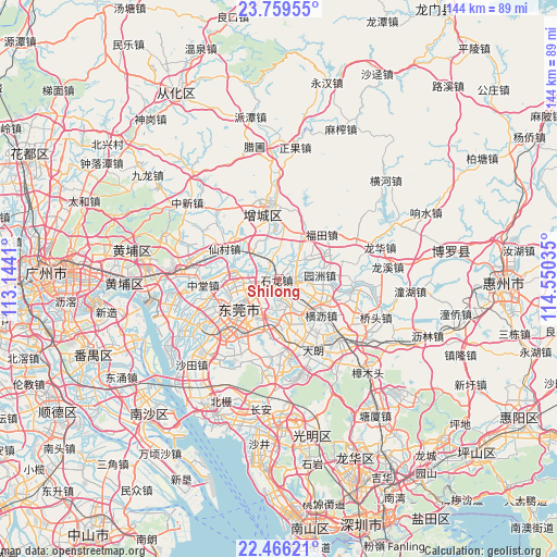
Shilong GPS coordinates[2]
23° 6' 51.984" North, 113° 50' 49.992" East
| Map corner | latitude | longitude |
|---|---|---|
| Upper-left | 23.75955°, | 113.1441° |
| Center: | 23.11444°, | 113.84722° |
| Lower-right: | 22.46621°, | 114.55035° |
| Map W x H: | 143.8×143.8 km | = 89.4×89.4mi |
| max Lat: | 53.31946° ⇑93.9% North |
| Shilong: | 23.11444° |
| min Lat: | ⇓6.1% South 18.22056° |
| min Long | Shilong | max Long |
| 75.07348° | 113.84722° | 134.28917° |
| W 47.7%⇐ | ⇒52.3% E |
Elevation
Elevation of Shilong is 14 m = 46 ft, and this is 470.8 m = 1545 ft below average elevation for this country.
| Max E: |
5622 m = 18445 ft | 86.2% |
| Avg. | 484.8 m = 1591 ft | |
| Shilong | 14 m = 46 ft | |
Min E: |
-3 m = -10 ft | 13.8% |
See also: Shilong elevation on elevation.city.
Geographical zone
Shilong is located in North Torrid zone (between Equator and Tropic of Cancer). Distance of this Northern Tropic circle is 35.8 km =22.2 mi to North.| Distance of | km | miles | from Shilong |
|---|---|---|---|
| North Pole | 7437 | 4621.1 | to North |
| Arctic Circle | 4831.1 | 3001.9 | to North |
| Tropic Cancer | 35.8 | 22.2 | to North |
| Equator | 2570.1 | 1597 | to South |


Nearby cities:
15 places around Shilong: (largest is in red/bold)
• Chashan
5.5 km =3.4 mi,  155°
155°
• Dongcheng
10 km =6.2 mi,  219°
219°
• Dongguan
14.7 km =9.1 mi, 223°
• Gaobu
13.6 km =8.5 mi,  255°
255°
• Hengli
14.4 km =8.9 mi,  131°
131°
• Liaobu
13.2 km =8.2 mi, 164°
• Nancheng
14.5 km =9 mi,  226°
226°
• Shazhuang
2.4 km =1.5 mi,  329°
329°
• Shijie
6 km =3.7 mi,  249°
249°
• Shipai
10.7 km =6.6 mi,  106°
106°
• Shitan
9.2 km =5.7 mi,  317°
317°
• Shiwan
2.9 km =1.8 mi,  11°
11°
• Wancheng
12.1 km =7.5 mi, 233°
• Wanjiangqu
13 km =8.1 mi,  240°
240°
• Yuanzhou
10.6 km =6.6 mi,  84°
84°
Sources, notices
• [Note1] Compared only with cities in China existing in our database
• [Src1] Map data: © OpenStreetMap contributors (CC-BY-SA)
• [Src2] Other city data from geonames.org with taken over terms of usage.
• [Src3] Geographical zone / Annual Mean Temperature by Robert A. Rohde @ Wikipedia
