Guandao geodata
Guandao (Shandong) is a seat of a fourth-order administrative division; located in China in Asia/Shanghai (GMT+8) time zone. In our database, there are 1268 cities with bigger population. Compared to other cities in China, 79.6% of cities are located further ↓South; 85.8% of cities are located further ←West and 57.5% of cities have higher elevation than Guandao. Note1


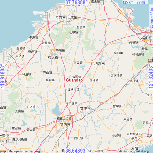
Guandao GPS coordinates[2]
37° 12' 39.528" North, 120° 37' 16.32" East
| Map corner | latitude | longitude |
|---|---|---|
| Upper-left | 37.76888°, | 119.91808° |
| Center: | 37.21098°, | 120.6212° |
| Lower-right: | 36.64893°, | 121.32433° |
| Map W x H: | 124.5×124.5 km | = 77.4×77.4mi |
| max Lat: | 53.31946° ⇑20.4% North |
| Guandao: | 37.21098° |
| min Lat: | ⇓79.6% South 18.22056° |
| min Long | Guandao | max Long |
| 75.07348° | 120.6212° | 134.28917° |
| W 85.8%⇐ | ⇒14.2% E |
Elevation
Elevation of Guandao is 114 m = 374 ft, and this is 370.8 m = 1217 ft below average elevation for this country.
| Max E: |
5622 m = 18445 ft | 57.5% |
| Avg. | 484.8 m = 1591 ft | |
| Guandao | 114 m = 374 ft | |
Min E: |
-3 m = -10 ft | 42.5% |
See also: China elevation on elevation.city.
Geographical zone
Guandao is located in North temperate zone (between Tropic of Cancer and the Arctic Circle). Distance of this Northern Tropic circle is 1531.6 km =951.7 mi to South.| Distance of | km | miles | from Guandao |
|---|---|---|---|
| North Pole | 5869.6 | 3647.2 | to North |
| Arctic Circle | 3263.7 | 2028 | to North |
| Tropic Cancer | 1531.6 | 951.7 | to South |
| Equator | 4137.5 | 2570.9 | to South |


Nearby cities:
15 places around Guandao: (largest is in red/bold)
• Biguo
6 km =3.7 mi,  279°
279°
• Daqinjia
21.9 km =13.6 mi,  318°
318°
• Fushan
21.6 km =13.4 mi,  344°
344°
• Guanli
6.9 km =4.3 mi,  114°
114°
• Hetoudian
21.8 km =13.5 mi,  191°
191°
• Malianzhuang
20.7 km =12.9 mi,  222°
222°
• Muyudian
23.3 km =14.5 mi,  149°
149°
• Shewopo
23.1 km =14.4 mi, 111°
• Sikou
11.9 km =7.4 mi,  5°
5°
• Sujiadian
23.8 km =14.8 mi, 11°
• Tangezhuang
10.6 km =6.6 mi, 194°
• Xiadian
21.7 km =13.5 mi,  263°
263°
• Xicheng
16.4 km =10.2 mi,  45°
45°
• Yangchu
14.3 km =8.9 mi,  99°
99°
• Zhuangyuan
21.1 km =13.1 mi,  60°
60°
Sources, notices
• [Note1] Compared only with cities in China existing in our database
• [Src1] Map data: © OpenStreetMap contributors (CC-BY-SA)
• [Src2] Other city data from geonames.org with taken over terms of usage.
• [Src3] Geographical zone / Annual Mean Temperature by Robert A. Rohde @ Wikipedia
