Shewopo geodata
Shewopo (Shandong) is a seat of a fourth-order administrative division; located in China in Asia/Shanghai (GMT+8) time zone. In our database, there are 1268 cities with bigger population. Compared to other cities in China, 79.5% of cities are located further ↓South; 87.2% of cities are located further ←West and 61.9% of cities have higher elevation than Shewopo. Note1


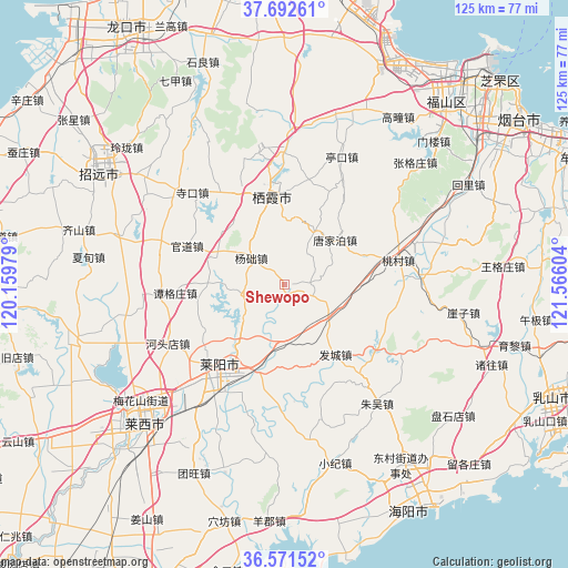
Shewopo GPS coordinates[2]
37° 8' 2.904" North, 120° 51' 46.476" East
| Map corner | latitude | longitude |
|---|---|---|
| Upper-left | 37.69261°, | 120.15979° |
| Center: | 37.13414°, | 120.86291° |
| Lower-right: | 36.57152°, | 121.56604° |
| Map W x H: | 124.7×124.7 km | = 77.5×77.5mi |
| max Lat: | 53.31946° ⇑20.5% North |
| Shewopo: | 37.13414° |
| min Lat: | ⇓79.5% South 18.22056° |
| min Long | Shewopo | max Long |
| 75.07348° | 120.86291° | 134.28917° |
| W 87.2%⇐ | ⇒12.8% E |
Elevation
Elevation of Shewopo is 88 m = 289 ft, and this is 396.8 m = 1302 ft below average elevation for this country.
| Max E: |
5622 m = 18445 ft | 61.9% |
| Avg. | 484.8 m = 1591 ft | |
| Shewopo | 88 m = 289 ft | |
Min E: |
-3 m = -10 ft | 38.1% |
See also: China elevation on elevation.city.
Geographical zone
Shewopo is located in North temperate zone (between Tropic of Cancer and the Arctic Circle). Distance of this Northern Tropic circle is 1523 km =946.3 mi to South.| Distance of | km | miles | from Shewopo |
|---|---|---|---|
| North Pole | 5878.1 | 3652.5 | to North |
| Arctic Circle | 3272.2 | 2033.3 | to North |
| Tropic Cancer | 1523 | 946.3 | to South |
| Equator | 4128.9 | 2565.6 | to South |


Nearby cities:
15 places around Shewopo: (largest is in red/bold)
• Biguo
29 km =18 mi,  289°
289°
• Guandao
23.1 km =14.4 mi, 291°
• Guanli
16.2 km =10.1 mi, 290°
• Hetoudian
28.7 km =17.8 mi,  243°
243°
• Laiyang
22 km =13.7 mi,  216°
216°
• Muyudian
15.1 km =9.4 mi, 220°
• Shanqiandian
13.4 km =8.3 mi,  177°
177°
• Sikou
28.7 km =17.8 mi,  315°
315°
• Songshan
30.7 km =19.1 mi,  359°
359°
• Tangezhuang
24.1 km =15 mi,  265°
265°
• Tangjiapo
14.8 km =9.2 mi,  47°
47°
• Xicheng
22.3 km =13.9 mi,  334°
334°
• Xujiadian
12.4 km =7.7 mi,  118°
118°
• Yangchu
9.6 km =6 mi,  310°
310°
• Zhuangyuan
19.3 km =12 mi,  350°
350°
Sources, notices
• [Note1] Compared only with cities in China existing in our database
• [Src1] Map data: © OpenStreetMap contributors (CC-BY-SA)
• [Src2] Other city data from geonames.org with taken over terms of usage.
• [Src3] Geographical zone / Annual Mean Temperature by Robert A. Rohde @ Wikipedia
