Jiuquan geodata
Jiuquan (Gansu) is a seat of a second-order administrative division; located in China in Asia/Shanghai (GMT+8) time zone. With population of 72,732 people, there are 588 cities with bigger population in this country. Compared to other cities in China, 85.5% of cities are located further ↓South; 95.3% of cities are located further →East and 91.1% of cities have lower elevation than Jiuquan. Note1


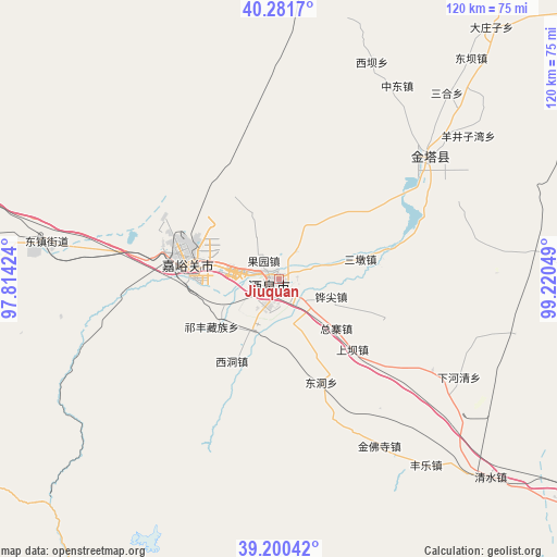
Jiuquan GPS coordinates[2]
39° 44' 35.448" North, 98° 31' 2.496" East
| Map corner | latitude | longitude |
|---|---|---|
| Upper-left | 40.2817°, | 97.81424° |
| Center: | 39.74318°, | 98.51736° |
| Lower-right: | 39.20042°, | 99.22049° |
| Map W x H: | 120.2×120.2 km | = 74.7×74.7mi |
| max Lat: | 53.31946° ⇑14.5% North |
| Jiuquan: | 39.74318° |
| min Lat: | ⇓85.5% South 18.22056° |
| min Long | Jiuquan | max Long |
| 75.07348° | 98.51736° | 134.28917° |
| W 4.7%⇐ | ⇒95.3% E |
Elevation
Elevation of Jiuquan is 1464 m = 4803 ft, and this is 979.2 m = 3213 ft above average elevation for this country.
| Max E: |
5622 m = 18445 ft | 8.9% |
| Jiuquan | 1464 m 4803 ft | |
| Avg. | 484.8 m = 1591 ft | |
Min E: |
-3 m = -10 ft | 91.1% |
See also: Jiuquan elevation on elevation.city.
Geographical zone
Jiuquan is located in North temperate zone (between Tropic of Cancer and the Arctic Circle). Distance of this Northern Tropic circle is 1813.1 km =1126.6 mi to South.| Distance of | km | miles | from Jiuquan |
|---|---|---|---|
| North Pole | 5588 | 3472.2 | to North |
| Arctic Circle | 2982.1 | 1853 | to North |
| Tropic Cancer | 1813.1 | 1126.6 | to South |
| Equator | 4419 | 2745.8 | to South |


Nearby cities:
15 places around Jiuquan: (largest is in red/bold)
• Dongdong
29.9 km =18.6 mi,  154°
154°
• Huangnibao
26 km =16.2 mi,  96°
96°
• Jiayuguan
21.2 km =13.2 mi,  290°
290°
• Jinfosi
46 km =28.6 mi, 146°
• Jinta
40 km =24.9 mi,  48°
48°
• Jinta
42.9 km =26.7 mi, 49°
• Linshui
23.9 km =14.9 mi,  77°
77°
• Qiwen
20.9 km =13 mi,  231°
231°
• Wenshu
13.6 km =8.5 mi,  246°
246°
• Xiaheqing
43.2 km =26.8 mi,  117°
117°
• Xiba
50.9 km =31.6 mi,  23°
23°
• Xidong
18.8 km =11.7 mi,  212°
212°
• Yangjingziwan
51.3 km =31.9 mi, 52°
• Zhongdong
49 km =30.4 mi,  31°
31°
• Zongzhai
15.7 km =9.8 mi, 153°
Sources, notices
• [Note1] Compared only with cities in China existing in our database
• [Src1] Map data: © OpenStreetMap contributors (CC-BY-SA)
• [Src2] Other city data from geonames.org with taken over terms of usage.
• [Src3] Geographical zone / Annual Mean Temperature by Robert A. Rohde @ Wikipedia
