Xiaheqing geodata
Xiaheqing (Gansu) is a seat of a fourth-order administrative division; located in China in Asia/Shanghai (GMT+8) time zone. In our database, there are 1268 cities with bigger population. Compared to other cities in China, 84.8% of cities are located further ↓South; 95.1% of cities are located further →East and 91% of cities have lower elevation than Xiaheqing. Note1


Xiaheqing GPS coordinates[2]
39° 34' 0.012" North, 98° 58' 0.012" East
| Map corner | latitude | longitude |
|---|---|---|
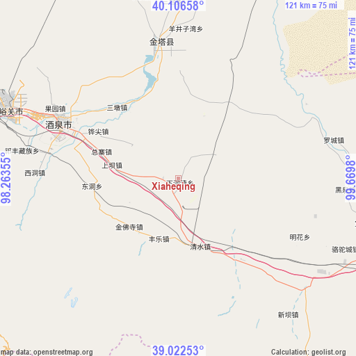
| Upper-left | 40.10658°, | 98.26355° |
| Center: | 39.56667°, | 98.96667° |
| Lower-right: | 39.02253°, | 99.6698° |
| Map W x H: | 120.5×120.5 km | = 74.9×74.9mi |
| max Lat: | 53.31946° ⇑15.2% North |
| Xiaheqing: | 39.56667° |
| min Lat: | ⇓84.8% South 18.22056° |
| min Long | Xiaheqing | max Long |
| 75.07348° | 98.96667° | 134.28917° |
| W 4.9%⇐ | ⇒95.1% E |
Elevation
Elevation of Xiaheqing is 1453 m = 4767 ft, and this is 968.2 m = 3177 ft above average elevation for this country.
| Max E: |
5622 m = 18445 ft | 9% |
| Xiaheqing | 1453 m 4767 ft | |
| Avg. | 484.8 m = 1591 ft | |
Min E: |
-3 m = -10 ft | 91% |
See also: China elevation on elevation.city.
Geographical zone
Xiaheqing is located in North temperate zone (between Tropic of Cancer and the Arctic Circle). Distance of this Northern Tropic circle is 1793.5 km =1114.4 mi to South.| Distance of | km | miles | from Xiaheqing |
|---|---|---|---|
| North Pole | 5607.7 | 3484.5 | to North |
| Arctic Circle | 3001.8 | 1865.2 | to North |
| Tropic Cancer | 1793.5 | 1114.4 | to South |
| Equator | 4399.4 | 2733.7 | to South |


Nearby cities:
15 places around Xiaheqing: (largest is in red/bold)
• Dongdong
26.8 km =16.7 mi,  253°
253°
• Huangnibao
21 km =13 mi,  323°
323°
• Jinfosi
22.6 km =14 mi,  214°
214°
• Jinta
47.1 km =29.3 mi,  349°
349°
• Jinta
47.6 km =29.6 mi, 353°
• Jiuquan
43.2 km =26.8 mi,  297°
297°
• Lianhua
13.6 km =8.5 mi,  57°
57°
• Linshui
29 km =18 mi,  328°
328°
• Luocheng
52 km =32.3 mi,  75°
75°
• Minghai
39.3 km =24.4 mi,  100°
100°
• Qingshui
24.9 km =15.5 mi,  144°
144°
• Wenshu
52.8 km =32.8 mi,  285°
285°
• Xidong
48.7 km =30.3 mi,  274°
274°
• Yangjingziwan
50.7 km =31.5 mi,  2°
2°
• Zongzhai
31.9 km =19.8 mi,  280°
280°
Sources, notices
• [Note1] Compared only with cities in China existing in our database
• [Src1] Map data: © OpenStreetMap contributors (CC-BY-SA)
• [Src2] Other city data from geonames.org with taken over terms of usage.
• [Src3] Geographical zone / Annual Mean Temperature by Robert A. Rohde @ Wikipedia
