Zhougao geodata
Zhougao (Anhui) is a seat of a fourth-order administrative division; located in China in Asia/Shanghai (GMT+8) time zone. In our database, there are 1268 cities with bigger population. Compared to other cities in China, 56% of cities are located further ↓South; 73.5% of cities are located further ←West and 91.2% of cities have higher elevation than Zhougao. Note1


Zhougao GPS coordinates[2]
31° 10' 27.156" North, 118° 32' 47.292" East
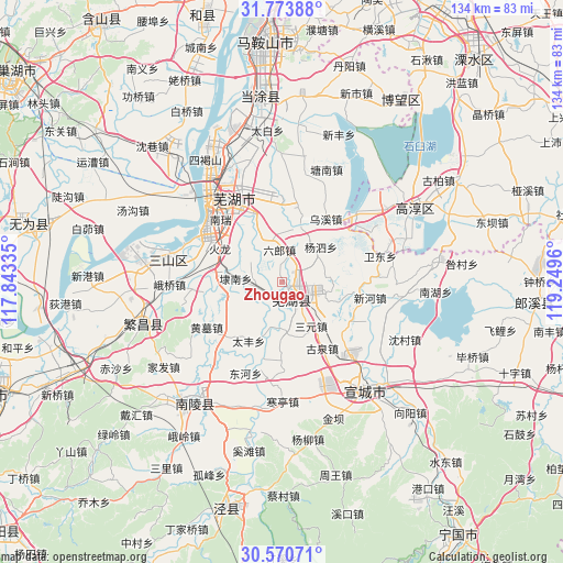
| Map corner | latitude | longitude |
|---|---|---|
| Upper-left | 31.77388°, | 117.84335° |
| Center: | 31.17421°, | 118.54647° |
| Lower-right: | 30.57071°, | 119.2496° |
| Map W x H: | 133.8×133.8 km | = 83.1×83.1mi |
| max Lat: | 53.31946° ⇑44% North |
| Zhougao: | 31.17421° |
| min Lat: | ⇓56% South 18.22056° |
| min Long | Zhougao | max Long |
| 75.07348° | 118.54647° | 134.28917° |
| W 73.5%⇐ | ⇒26.5% E |
Elevation
Elevation of Zhougao is 9 m = 30 ft, and this is 475.8 m = 1561 ft below average elevation for this country.
| Max E: |
5622 m = 18445 ft | 91.2% |
| Avg. | 484.8 m = 1591 ft | |
| Zhougao | 9 m = 30 ft | |
Min E: |
-3 m = -10 ft | 8.8% |
See also: China elevation on elevation.city.
Geographical zone
Zhougao is located in North temperate zone (between Tropic of Cancer and the Arctic Circle). Distance of this Northern Tropic circle is 860.3 km =534.6 mi to South.| Distance of | km | miles | from Zhougao |
|---|---|---|---|
| North Pole | 6540.8 | 4064.3 | to North |
| Arctic Circle | 3934.9 | 2445 | to North |
| Tropic Cancer | 860.3 | 534.6 | to South |
| Equator | 3466.2 | 2153.8 | to South |


Nearby cities:
15 places around Zhougao: (largest is in red/bold)
• Dainan
11 km =6.8 mi,  274°
274°
• Huangchi
15.1 km =9.4 mi,  19°
19°
• Huaqiao
13.9 km =8.6 mi,  84°
84°
• Kuihu
13.4 km =8.3 mi,  258°
258°
• Liulang
7.7 km =4.8 mi,  355°
355°
• Sanyuan
12.6 km =7.8 mi,  146°
146°
• Taifeng
16.1 km =10 mi,  209°
209°
• Taoxin
6 km =3.7 mi, 255°
• Wanzhi
3.6 km =2.2 mi, 147°
• Wuhu
3.6 km =2.2 mi, 150°
• Xianbao
11.3 km =7 mi,  351°
351°
• Xinfeng
13.4 km =8.3 mi,  108°
108°
• Yitai
12.7 km =7.9 mi,  333°
333°
• Zhangzhen
14.8 km =9.2 mi, 354°
• Zhaoqiao
5.2 km =3.2 mi,  42°
42°
Sources, notices
• [Note1] Compared only with cities in China existing in our database
• [Src1] Map data: © OpenStreetMap contributors (CC-BY-SA)
• [Src2] Other city data from geonames.org with taken over terms of usage.
• [Src3] Geographical zone / Annual Mean Temperature by Robert A. Rohde @ Wikipedia
