Chengkan geodata
Chengkan (Anhui) is a seat of a fourth-order administrative division; located in China in Asia/Shanghai (GMT+8) time zone. In our database, there are 1268 cities with bigger population. Compared to other cities in China, 54.8% of cities are located further ↑North; 71.9% of cities are located further ←West and 53.3% of cities have lower elevation than Chengkan. Note1


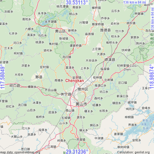
Chengkan GPS coordinates[2]
29° 55' 24.996" North, 118° 17' 0.996" East
| Map corner | latitude | longitude |
|---|---|---|
| Upper-left | 30.53113°, | 117.58049° |
| Center: | 29.92361°, | 118.28361° |
| Lower-right: | 29.31236°, | 118.98674° |
| Map W x H: | 135.5×135.5 km | = 84.2×84.2mi |
| max Lat: | 53.31946° ⇑54.8% North |
| Chengkan: | 29.92361° |
| min Lat: | ⇓45.2% South 18.22056° |
| min Long | Chengkan | max Long |
| 75.07348° | 118.28361° | 134.28917° |
| W 71.9%⇐ | ⇒28.1% E |
Elevation
Elevation of Chengkan is 191 m = 627 ft, and this is 293.8 m = 964 ft below average elevation for this country.
| Max E: |
5622 m = 18445 ft | 46.7% |
| Avg. | 484.8 m = 1591 ft | |
| Chengkan | 191 m = 627 ft | |
Min E: |
-3 m = -10 ft | 53.3% |
See also: China elevation on elevation.city.
Geographical zone
Chengkan is located in North temperate zone (between Tropic of Cancer and the Arctic Circle). Distance of this Northern Tropic circle is 721.3 km =448.2 mi to South.| Distance of | km | miles | from Chengkan |
|---|---|---|---|
| North Pole | 6679.9 | 4150.7 | to North |
| Arctic Circle | 4074 | 2531.5 | to North |
| Tropic Cancer | 721.3 | 448.2 | to South |
| Equator | 3327.2 | 2067.4 | to South |


Nearby cities:
15 places around Chengkan: (largest is in red/bold)
• Fuxi
11 km =6.8 mi,  322°
322°
• Fu’e
8.9 km =5.5 mi,  101°
101°
• Guilin
17.8 km =11.1 mi,  90°
90°
• Haiyang
18.4 km =11.4 mi,  213°
213°
• Huangcun
15.4 km =9.6 mi,  48°
48°
• Huicheng
15.7 km =9.8 mi,  112°
112°
• Lantian
19 km =11.8 mi,  264°
264°
• Qiankou
6 km =3.7 mi,  169°
169°
• Shangfeng
10.4 km =6.5 mi,  39°
39°
• Tunguang
18.9 km =11.7 mi,  157°
157°
• Wan’an
16.1 km =10 mi,  204°
204°
• Xiongcun
19 km =11.8 mi,  128°
128°
• Xucun
8.8 km =5.5 mi,  20°
20°
• Yansi
12.3 km =7.6 mi,  154°
154°
• Zhengcun
11.5 km =7.1 mi, 128°
Sources, notices
• [Note1] Compared only with cities in China existing in our database
• [Src1] Map data: © OpenStreetMap contributors (CC-BY-SA)
• [Src2] Other city data from geonames.org with taken over terms of usage.
• [Src3] Geographical zone / Annual Mean Temperature by Robert A. Rohde @ Wikipedia
