Huangcun geodata
Huangcun (Anhui) is a seat of a fourth-order administrative division; located in China in Asia/Shanghai (GMT+8) time zone. In our database, there are 1268 cities with bigger population. Compared to other cities in China, 53.8% of cities are located further ↑North; 72.6% of cities are located further ←West and 63% of cities have lower elevation than Huangcun. Note1


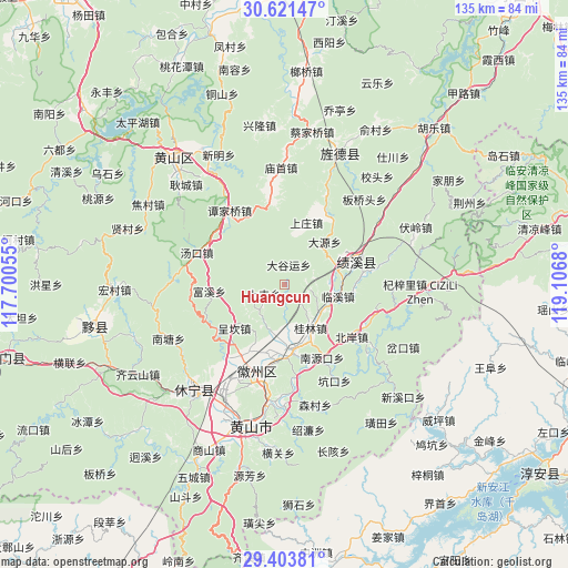
Huangcun GPS coordinates[2]
30° 0' 52.236" North, 118° 24' 13.212" East
| Map corner | latitude | longitude |
|---|---|---|
| Upper-left | 30.62147°, | 117.70055° |
| Center: | 30.01451°, | 118.40367° |
| Lower-right: | 29.40381°, | 119.1068° |
| Map W x H: | 135.4×135.4 km | = 84.1×84.1mi |
| max Lat: | 53.31946° ⇑53.8% North |
| Huangcun: | 30.01451° |
| min Lat: | ⇓46.2% South 18.22056° |
| min Long | Huangcun | max Long |
| 75.07348° | 118.40367° | 134.28917° |
| W 72.6%⇐ | ⇒27.4% E |
Elevation
Elevation of Huangcun is 296 m = 971 ft, and this is 188.8 m = 619 ft below average elevation for this country.
| Max E: |
5622 m = 18445 ft | 37% |
| Avg. | 484.8 m = 1591 ft | |
| Huangcun | 296 m = 971 ft | |
Min E: |
-3 m = -10 ft | 63% |
See also: China elevation on elevation.city.
Geographical zone
Huangcun is located in North temperate zone (between Tropic of Cancer and the Arctic Circle). Distance of this Northern Tropic circle is 731.4 km =454.5 mi to South.| Distance of | km | miles | from Huangcun |
|---|---|---|---|
| North Pole | 6669.8 | 4144.4 | to North |
| Arctic Circle | 4063.9 | 2525.2 | to North |
| Tropic Cancer | 731.4 | 454.5 | to South |
| Equator | 3337.3 | 2073.7 | to South |


Nearby cities:
15 places around Huangcun: (largest is in red/bold)
• Chang’an
18.9 km =11.7 mi,  35°
35°
• Chengcunjiang
19 km =11.8 mi,  137°
137°
• Chengkan
15.4 km =9.6 mi,  228°
228°
• Daguyun
5.5 km =3.4 mi,  18°
18°
• Fuxi
18.3 km =11.4 mi,  265°
265°
• Fu’e
12.2 km =7.6 mi,  193°
193°
• Guilin
12 km =7.5 mi,  148°
148°
• Huayang
19 km =11.8 mi,  70°
70°
• Huicheng
16.4 km =10.2 mi,  169°
169°
• Linxi
13 km =8.1 mi,  102°
102°
• Shangfeng
5.3 km =3.3 mi,  246°
246°
• Shangzhuang
12.6 km =7.8 mi,  13°
13°
• Xitou
6.1 km =3.8 mi,  94°
94°
• Xucun
8.6 km =5.3 mi,  257°
257°
• Zhengcun
17.4 km =10.8 mi, 188°
Sources, notices
• [Note1] Compared only with cities in China existing in our database
• [Src1] Map data: © OpenStreetMap contributors (CC-BY-SA)
• [Src2] Other city data from geonames.org with taken over terms of usage.
• [Src3] Geographical zone / Annual Mean Temperature by Robert A. Rohde @ Wikipedia
