Puerto Nariño geodata
Puerto Nariño (Amazonas) is a populated place; located in Colombia in America/Bogota (GMT-5) time zone. With population of 2,113 people, there are 784 cities with bigger population in this country. Compared to other cities in Colombia, 99.9% of cities are located further ↑North; 99.3% of cities are located further ←West and 82% of cities have higher elevation than Puerto Nariño. Note1


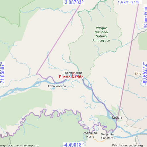
Puerto Nariño GPS coordinates[2]
3° 47' 20.004" South, 70° 21' 21.024" West
| Map corner | latitude | longitude |
|---|---|---|
| Upper-left | -3.08703°, | -71.05897° |
| Center: | -3.78889°, | -70.35584° |
| Lower-right: | -4.49018°, | -69.65272° |
| Map W x H: | 156×156 km | = 96.9×96.9mi |
| max Lat: | 13.38166° ⇑99.9% North |
| Puerto Nariño: | -3.78889° |
| min Lat: | ⇓0.1% South -4.21528° |
| min Long | Puerto Nariño | max Long |
| -81.70636° | -70.35584° | -67.06996° |
| W 99.3%⇐ | ⇒0.7% E |
Elevation
Elevation of Puerto Nariño is 92 m = 302 ft, and this is 1057.3 m = 3469 ft below average elevation for this country.
| Max E: |
3342 m = 10965 ft | 82% |
| Avg. | 1149.3 m = 3771 ft | |
| Puerto Nariño | 92 m = 302 ft | |
Min E: |
1 m = 3 ft | 18% |
See also: Colombia elevation on elevation.city.
Geographical zone
Puerto Nariño is located in South Torrid zone (between Equator and Tropic of Capricorn). Distance of Equator is 421.3 km =261.8 mi to North.| Distance of | km | miles | from Puerto Nariño |
|---|---|---|---|
| Equator | 421.3 | 261.8 | to North |
| Tropic Capricorn | 2184.6 | 1357.4 | to South |
| Antarctic Circle | 6979.9 | 4337.1 | to South |
| South Pole | 9585.8 | 5956.3 | to South |


Nearby cities:
2 places around Puerto Nariño: (largest is in red/bold)
• Leticia
66.1 km =41.1 mi,  135°
135°
• Tarapacá
120.8 km =75.1 mi,  34°
34°
Sources, notices
• [Note1] Compared only with cities in Colombia existing in our database
• [Src1] Map data: © OpenStreetMap contributors (CC-BY-SA)
• [Src2] Other city data from geonames.org with taken over terms of usage.
• [Src3] Geographical zone / Annual Mean Temperature by Robert A. Rohde @ Wikipedia
