Leticia geodata
Leticia (Amazonas) is a seat of a first-order administrative division; located in Colombia in America/Bogota (GMT-5) time zone. With population of 29,666 people, there are 121 cities with bigger population in this country. Compared to other cities in Colombia, 100% of cities are located further ↑North; 99.6% of cities are located further ←West and 83.3% of cities have higher elevation than Leticia. Note1


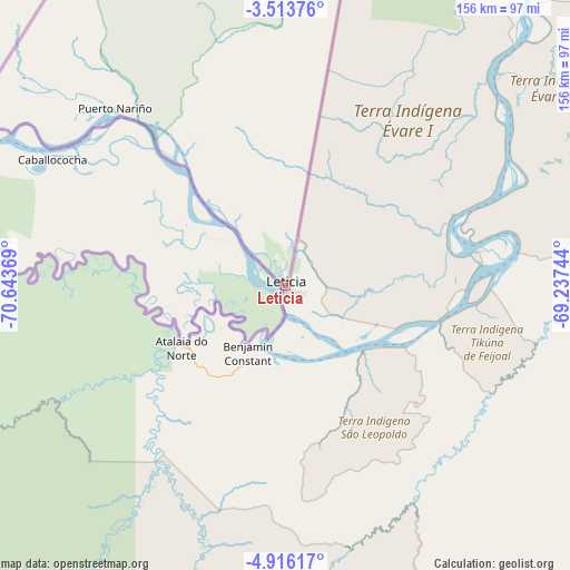
Leticia GPS coordinates[2]
4° 12' 55.008" South, 69° 56' 26.016" West
| Map corner | latitude | longitude |
|---|---|---|
| Upper-left | -3.51376°, | -70.64369° |
| Center: | -4.21528°, | -69.94056° |
| Lower-right: | -4.91617°, | -69.23744° |
| Map W x H: | 155.9×155.9 km | = 96.9×96.9mi |
| max Lat: | 13.38166° ⇑100% North |
| Leticia: | -4.21528° |
| min Lat: | ⇓0% South -4.21528° |
| min Long | Leticia | max Long |
| -81.70636° | -69.94056° | -67.06996° |
| W 99.6%⇐ | ⇒0.40000000000001% E |
Elevation
Elevation of Leticia is 82 m = 269 ft, and this is 1067.3 m = 3502 ft below average elevation for this country.
| Max E: |
3342 m = 10965 ft | 83.3% |
| Avg. | 1149.3 m = 3771 ft | |
| Leticia | 82 m = 269 ft | |
Min E: |
1 m = 3 ft | 16.7% |
See also: Colombia elevation on elevation.city.
Geographical zone
Leticia is located in South Torrid zone (between Equator and Tropic of Capricorn). Distance of Equator is 468.7 km =291.2 mi to North.| Distance of | km | miles | from Leticia |
|---|---|---|---|
| Equator | 468.7 | 291.2 | to North |
| Tropic Capricorn | 2137.2 | 1328 | to South |
| Antarctic Circle | 6932.5 | 4307.7 | to South |
| South Pole | 9538.4 | 5926.9 | to South |


Nearby cities:
2 places around Leticia: (largest is in red/bold)
• Puerto Nariño
66.1 km =41.1 mi,  315°
315°
• Tarapacá
148.8 km =92.5 mi,  8°
8°
Sources, notices
• [Note1] Compared only with cities in Colombia existing in our database
• [Src1] Map data: © OpenStreetMap contributors (CC-BY-SA)
• [Src2] Other city data from geonames.org with taken over terms of usage.
• [Src3] Geographical zone / Annual Mean Temperature by Robert A. Rohde @ Wikipedia
