Barber geodata
Barber is a populated place; located in Curacao in America/Curacao (GMT-4) time zone. With population of 2,424 people, there are 2 cities with bigger population in this country. Compared to other cities in Curacao, 75% of cities are located further ↓South; 50% of cities are located further ←West and 100% of cities have lower elevation than Barber. Note1


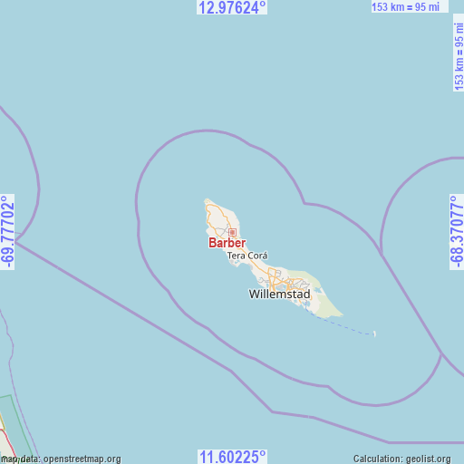
Barber GPS coordinates[2]
12° 17' 24.504" North, 69° 4' 26.004" West
| Map corner | latitude | longitude |
|---|---|---|
| Upper-left | 12.97624°, | -69.77702° |
| Center: | 12.29014°, | -69.07389° |
| Lower-right: | 11.60225°, | -68.37077° |
| Map W x H: | 152.8×152.8 km | = 94.9×94.9mi |
| max Lat: | 12.37047° ⇑25% North |
| Barber: | 12.29014° |
| min Lat: | ⇓75% South 12.1084° |
| min Long | Barber | max Long |
| -69.15405° | -69.07389° | -68.93354° |
| W 50%⇐ | ⇒50% E |
Elevation
Elevation of Barber is 25 m = 82 ft, and this is 9.8 m = 32 ft above average elevation for this country.
| Max E: |
25 m = 82 ft | 0% |
| Barber | 25 m 82 ft | |
| Avg. | 15.2 m = 50 ft | |
Min E: |
1 m = 3 ft | 100% |
See also: Curacao elevation on elevation.city.
Geographical zone
Barber is located in North Torrid zone (between Equator and Tropic of Cancer). Distance of this Northern Tropic circle is 1239.4 km =770.1 mi to North.| Distance of | km | miles | from Barber |
|---|---|---|---|
| North Pole | 8640.5 | 5369 | to North |
| Arctic Circle | 6034.6 | 3749.7 | to North |
| Tropic Cancer | 1239.4 | 770.1 | to North |
| Equator | 1366.5 | 849.1 | to South |


Nearby cities:
4 places around Barber: (largest is in red/bold)
• Dorp Soto
4.4 km =2.7 mi,  251°
251°
• Sabana Westpunt
12.5 km =7.8 mi,  315°
315°
• Sint Michiel Liber
18.4 km =11.4 mi,  147°
147°
• Willemstad
25.3 km =15.7 mi,  142°
142°
Sources, notices
• [Note1] Compared only with cities in Curacao existing in our database
• [Src1] Map data: © OpenStreetMap contributors (CC-BY-SA)
• [Src2] Other city data from geonames.org with taken over terms of usage.
• [Src3] Geographical zone / Annual Mean Temperature by Robert A. Rohde @ Wikipedia
