Zátor geodata
Zátor (Moravskoslezský) is a populated place; located in Czech Republic in Europe/Prague (GMT+2) time zone. With population of 1,169 people, there are 1105 cities with bigger population in this country. Compared to other cities in Czech Republic, 67.9% of cities are located further ↓South; 86.9% of cities are located further ←West and 68.8% of cities have lower elevation than Zátor. Note1


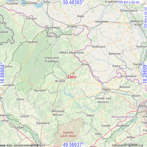
Zátor GPS coordinates[2]
50° 2' 2.868" North, 17° 35' 34.656" East
| Map corner | latitude | longitude |
|---|---|---|
| Upper-left | 50.48365°, | 16.88984° |
| Center: | 50.03413°, | 17.59296° |
| Lower-right: | 49.58037°, | 18.29609° |
| Map W x H: | 100.4×100.4 km | = 62.4×62.4mi |
| max Lat: | 51.01104° ⇑32.1% North |
| Zátor: | 50.03413° |
| min Lat: | ⇓67.9% South 48.60378° |
| min Long | Zátor | max Long |
| 12.17577° | 17.59296° | 18.82683° |
| W 86.9%⇐ | ⇒13.1% E |
Elevation
Elevation of Zátor is 410 m = 1345 ft, and this is 58 m = 190 ft above average elevation for this country.
| Max E: |
901 m = 2956 ft | 31.2% |
| Zátor | 410 m 1345 ft | |
| Avg. | 352 m = 1155 ft | |
Min E: |
136 m = 446 ft | 68.8% |
See also: Czech Republic elevation on elevation.city.
Geographical zone
Zátor is located in North temperate zone (between Tropic of Cancer and the Arctic Circle). Distance of this North polar circle is 1837.9 km =1142 mi to North.| Distance of | km | miles | from Zátor |
|---|---|---|---|
| North Pole | 4443.8 | 2761.2 | to North |
| Arctic Circle | 1837.9 | 1142 | to North |
| Tropic Cancer | 2957.4 | 1837.6 | to South |
| Equator | 5563.3 | 3456.9 | to South |


Nearby cities:
15 places around Zátor: (largest is in red/bold)
• Brantice
4.2 km =2.6 mi,  38°
38°
• Brumovice
11.4 km =7.1 mi,  100°
100°
• Bruntál
10.5 km =6.5 mi,  240°
240°
• Horní Benešov
7.5 km =4.7 mi,  174°
174°
• Hošťálkovy
8.6 km =5.3 mi,  3°
3°
• Karlovice
13.2 km =8.2 mi,  307°
307°
• Krnov
10 km =6.2 mi,  52°
52°
• Lichnov
3.8 km =2.4 mi,  140°
140°
• Město Albrechtice
14.4 km =8.9 mi,  354°
354°
• Razová
12.2 km =7.6 mi,  200°
200°
• Staré Město
12 km =7.5 mi,  253°
253°
• Svobodné Heřmanice
11.4 km =7.1 mi,  149°
149°
• Velké Heraltice
11.7 km =7.3 mi,  124°
124°
• Úvalno
10.9 km =6.8 mi,  82°
82°
• Široká Niva
8.7 km =5.4 mi,  293°
293°
Sources, notices
• [Note1] Compared only with cities in Czech Republic existing in our database
• [Src1] Map data: © OpenStreetMap contributors (CC-BY-SA)
• [Src2] Other city data from geonames.org with taken over terms of usage.
• [Src3] Geographical zone / Annual Mean Temperature by Robert A. Rohde @ Wikipedia
