Vrbno pod Pradědem geodata
Vrbno pod Pradědem (Moravskoslezský) is a populated place; located in Czech Republic in Europe/Prague (GMT+2) time zone. With population of 6,072 people, there are 228 cities with bigger population in this country. Compared to other cities in Czech Republic, 73.2% of cities are located further ↓South; 83.2% of cities are located further ←West and 90% of cities have lower elevation than Vrbno pod Pradědem. Note1
Administrative division(s):
- Level 1: Moravskoslezský
- Level 2: Okres Bruntál
- Level 3: Vrbno pod Pradědem


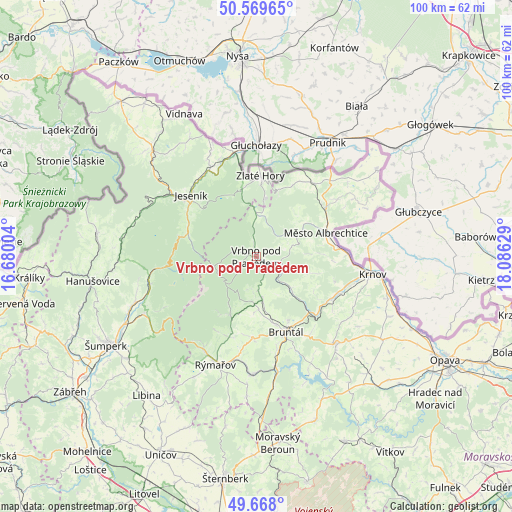
Vrbno pod Pradědem GPS coordinates[2]
50° 7' 15.42" North, 17° 22' 59.376" East
| Map corner | latitude | longitude |
|---|---|---|
| Upper-left | 50.56965°, | 16.68004° |
| Center: | 50.12095°, | 17.38316° |
| Lower-right: | 49.668°, | 18.08629° |
| Map W x H: | 100.3×100.3 km | = 62.3×62.3mi |
| max Lat: | 51.01104° ⇑26.8% North |
| Vrbno pod Pradědem: | 50.12095° |
| min Lat: | ⇓73.2% South 48.60378° |
| min Long | Vrbno pod Prad� | max Long |
| 12.17577° | 17.38316° | 18.82683° |
| W 83.2%⇐ | ⇒16.8% E |
Elevation
Elevation of Vrbno pod Pradědem is 528 m = 1732 ft, and this is 176 m = 577 ft above average elevation for this country.
| Max E: |
901 m = 2956 ft | 10% |
| Vrbno pod Pradědem | 528 m 1732 ft | |
| Avg. | 352 m = 1155 ft | |
Min E: |
136 m = 446 ft | 90% |
See also: Czech Republic elevation on elevation.city.
Geographical zone
Vrbno pod Pradědem is located in North temperate zone (between Tropic of Cancer and the Arctic Circle). Distance of this North polar circle is 1828.2 km =1136 mi to North.| Distance of | km | miles | from Vrbno pod Pradědem |
|---|---|---|---|
| North Pole | 4434.1 | 2755.2 | to North |
| Arctic Circle | 1828.2 | 1136 | to North |
| Tropic Cancer | 2967 | 1843.6 | to South |
| Equator | 5572.9 | 3462.8 | to South |


Nearby cities:
15 places around Vrbno pod Pradědem: (largest is in red/bold)
• Brantice
18.7 km =11.6 mi,  110°
110°
• Bruntál
15.8 km =9.8 mi,  158°
158°
• Hošťálkovy
15.5 km =9.6 mi,  93°
93°
• Jeseník
17.5 km =10.9 mi,  313°
313°
• Jindřichov
17.5 km =10.9 mi,  33°
33°
• Karlovice
4.8 km =3 mi, 110°
• Malá Morávka
12.7 km =7.9 mi,  202°
202°
• Město Albrechtice
14.4 km =8.9 mi,  71°
71°
• Písečná
19.3 km =12 mi,  331°
331°
• Staré Město
13.5 km =8.4 mi,  165°
165°
• Třemešná
16.6 km =10.3 mi,  55°
55°
• Zlaté Hory
15.9 km =9.9 mi,  3°
3°
• Zátor
17.8 km =11.1 mi,  122°
122°
• Česká Ves
18.8 km =11.7 mi,  323°
323°
• Široká Niva
9.4 km =5.8 mi,  131°
131°
Sources, notices
• [Note1] Compared only with cities in Czech Republic existing in our database
• [Src1] Map data: © OpenStreetMap contributors (CC-BY-SA)
• [Src2] Other city data from geonames.org with taken over terms of usage.
• [Src3] Geographical zone / Annual Mean Temperature by Robert A. Rohde @ Wikipedia
