Vodňany geodata
Vodňany (Jihočeský kraj) is a populated place; located in Czech Republic in Europe/Prague (GMT+2) time zone. With population of 6,687 people, there are 208 cities with bigger population in this country. Compared to other cities in Czech Republic, 83.8% of cities are located further ↑North; 80.2% of cities are located further →East and 67.5% of cities have lower elevation than Vodňany. Note1


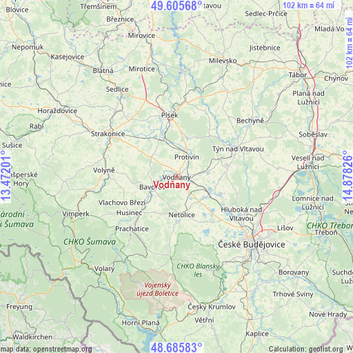
Vodňany GPS coordinates[2]
49° 8' 52.404" North, 14° 10' 30.468" East
| Map corner | latitude | longitude |
|---|---|---|
| Upper-left | 49.60568°, | 13.47201° |
| Center: | 49.14789°, | 14.17513° |
| Lower-right: | 48.68583°, | 14.87826° |
| Map W x H: | 102.3×102.3 km | = 63.6×63.6mi |
| max Lat: | 51.01104° ⇑83.8% North |
| Vodňany: | 49.14789° |
| min Lat: | ⇓16.2% South 48.60378° |
| min Long | Vodňany | max Long |
| 12.17577° | 14.17513° | 18.82683° |
| W 19.8%⇐ | ⇒80.2% E |
Elevation
Elevation of Vodňany is 405 m = 1329 ft, and this is 53 m = 174 ft above average elevation for this country.
| Max E: |
901 m = 2956 ft | 32.5% |
| Vodňany | 405 m 1329 ft | |
| Avg. | 352 m = 1155 ft | |
Min E: |
136 m = 446 ft | 67.5% |
See also: Czech Republic elevation on elevation.city.
Geographical zone
Vodňany is located in North temperate zone (between Tropic of Cancer and the Arctic Circle). Distance of this North polar circle is 1936.4 km =1203.2 mi to North.| Distance of | km | miles | from Vodňany |
|---|---|---|---|
| North Pole | 4542.3 | 2822.5 | to North |
| Arctic Circle | 1936.4 | 1203.2 | to North |
| Tropic Cancer | 2858.8 | 1776.4 | to South |
| Equator | 5464.7 | 3395.6 | to South |


Nearby cities:
15 places around Vodňany: (largest is in red/bold)
• Albrechtice nad Vltavou
14.9 km =9.3 mi,  38°
38°
• Bavorov
7.6 km =4.7 mi,  247°
247°
• Dívčice
10.7 km =6.6 mi,  114°
114°
• Dřiteň
12.4 km =7.7 mi,  92°
92°
• Husinec
17.2 km =10.7 mi,  232°
232°
• Lhenice
17.1 km =10.6 mi,  186°
186°
• Malovice
7.3 km =4.5 mi,  149°
149°
• Netolice
11.1 km =6.9 mi,  171°
171°
• Olešník
14.5 km =9 mi, 108°
• Protivín
6.5 km =4 mi,  28°
28°
• Strunkovice nad Blanicí
11.3 km =7 mi, 230°
• Temelín
13.6 km =8.5 mi,  68°
68°
• Všemyslice
15.3 km =9.5 mi,  59°
59°
• Zliv
16.6 km =10.3 mi,  123°
123°
• Čejetice
16.2 km =10.1 mi,  316°
316°
Sources, notices
• [Note1] Compared only with cities in Czech Republic existing in our database
• [Src1] Map data: © OpenStreetMap contributors (CC-BY-SA)
• [Src2] Other city data from geonames.org with taken over terms of usage.
• [Src3] Geographical zone / Annual Mean Temperature by Robert A. Rohde @ Wikipedia
