Strunkovice nad Blanicí geodata
Strunkovice nad Blanicí (Jihočeský kraj) is a populated place; located in Czech Republic in Europe/Prague (GMT+2) time zone. With population of 1,230 people, there are 1050 cities with bigger population in this country. Compared to other cities in Czech Republic, 87.4% of cities are located further ↑North; 82.3% of cities are located further →East and 79.3% of cities have lower elevation than Strunkovice nad Blanicí. Note1
Administrative division(s):
- Level 1: Jihočeský kraj
- Level 2: Okres Prachatice
- Level 3: Strunkovice nad Blanicí
Current local time in Strunkovice nad Blanicí:
04:27 AM, SaturdayDifference from your time zone: hours


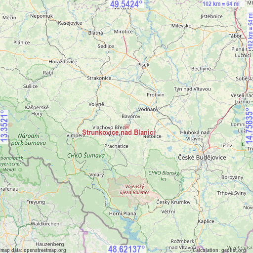
Strunkovice nad Blanicí GPS coordinates[2]
49° 5' 2.472" North, 14° 3' 18.792" East
| Map corner | latitude | longitude |
|---|---|---|
| Upper-left | 49.5424°, | 13.3521° |
| Center: | 49.08402°, | 14.05522° |
| Lower-right: | 48.62137°, | 14.75835° |
| Map W x H: | 102.4×102.4 km | = 63.6×63.6mi |
| max Lat: | 51.01104° ⇑87.4% North |
| Strunkovice nad Blanicí: | 49.08402° |
| min Lat: | ⇓12.6% South 48.60378° |
| min Long | Strunkovice nad | max Long |
| 12.17577° | 14.05522° | 18.82683° |
| W 17.7%⇐ | ⇒82.3% E |
Elevation
Elevation of Strunkovice nad Blanicí is 461 m = 1512 ft, and this is 109 m = 358 ft above average elevation for this country.
| Max E: |
901 m = 2956 ft | 20.7% |
| Strunkovice nad Blanicí | 461 m 1512 ft | |
| Avg. | 352 m = 1155 ft | |
Min E: |
136 m = 446 ft | 79.3% |
See also: Czech Republic elevation on elevation.city.
Geographical zone
Strunkovice nad Blanicí is located in North temperate zone (between Tropic of Cancer and the Arctic Circle). Distance of this North polar circle is 1943.5 km =1207.6 mi to North.| Distance of | km | miles | from Strunkovice nad Blanicí |
|---|---|---|---|
| North Pole | 4549.4 | 2826.9 | to North |
| Arctic Circle | 1943.5 | 1207.6 | to North |
| Tropic Cancer | 2851.7 | 1772 | to South |
| Equator | 5457.6 | 3391.2 | to South |


Nearby cities:
15 places around Strunkovice nad Blanicí: (largest is in red/bold)
• Bavorov
4.5 km =2.8 mi,  22°
22°
• Dívčice
18.7 km =11.6 mi,  81°
81°
• Husinec
5.9 km =3.7 mi,  236°
236°
• Lhenice
12.1 km =7.5 mi,  145°
145°
• Malenice
13.4 km =8.3 mi,  290°
290°
• Malovice
12.4 km =7.7 mi,  86°
86°
• Netolice
11 km =6.8 mi,  110°
110°
• Prachatice
9 km =5.6 mi,  208°
208°
• Protivín
17.4 km =10.8 mi,  42°
42°
• Svatá Maří
16.4 km =10.2 mi,  262°
262°
• Vlachovo Březí
7.1 km =4.4 mi,  267°
267°
• Vodňany
11.3 km =7 mi,  50°
50°
• Volyně
15.3 km =9.5 mi,  306°
306°
• Čejetice
18.9 km =11.7 mi,  352°
352°
• Čkyně
16.8 km =10.4 mi,  281°
281°
Sources, notices
• [Note1] Compared only with cities in Czech Republic existing in our database
• [Src1] Map data: © OpenStreetMap contributors (CC-BY-SA)
• [Src2] Other city data from geonames.org with taken over terms of usage.
• [Src3] Geographical zone / Annual Mean Temperature by Robert A. Rohde @ Wikipedia
