Včelákov geodata
Včelákov (Pardubický) is a populated place; located in Czech Republic in Europe/Prague (GMT+2) time zone. With population of 550 people, there are 2309 cities with bigger population in this country. Compared to other cities in Czech Republic, 52.8% of cities are located further ↓South; 53.2% of cities are located further ←West and 83.9% of cities have lower elevation than Včelákov. Note1


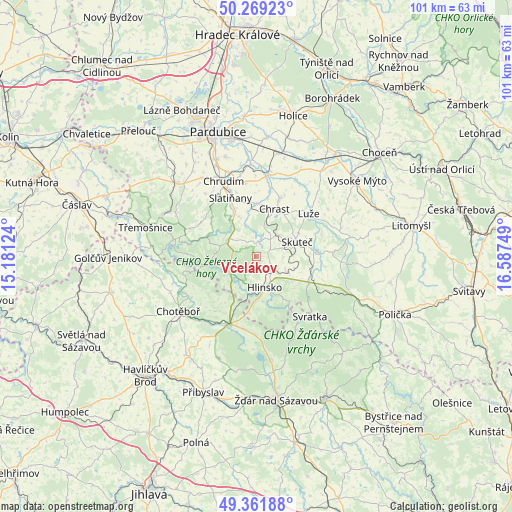
Včelákov GPS coordinates[2]
49° 49' 3.648" North, 15° 53' 3.696" East
| Map corner | latitude | longitude |
|---|---|---|
| Upper-left | 50.26923°, | 15.18124° |
| Center: | 49.81768°, | 15.88436° |
| Lower-right: | 49.36188°, | 16.58749° |
| Map W x H: | 100.9×100.9 km | = 62.7×62.7mi |
| max Lat: | 51.01104° ⇑47.2% North |
| Včelákov: | 49.81768° |
| min Lat: | ⇓52.8% South 48.60378° |
| min Long | Včelákov | max Long |
| 12.17577° | 15.88436° | 18.82683° |
| W 53.2%⇐ | ⇒46.8% E |
Elevation
Elevation of Včelákov is 487 m = 1598 ft, and this is 135 m = 443 ft above average elevation for this country.
| Max E: |
901 m = 2956 ft | 16.1% |
| Včelákov | 487 m 1598 ft | |
| Avg. | 352 m = 1155 ft | |
Min E: |
136 m = 446 ft | 83.9% |
See also: Czech Republic elevation on elevation.city.
Geographical zone
Včelákov is located in North temperate zone (between Tropic of Cancer and the Arctic Circle). Distance of this North polar circle is 1862 km =1157 mi to North.| Distance of | km | miles | from Včelákov |
|---|---|---|---|
| North Pole | 4467.9 | 2776.2 | to North |
| Arctic Circle | 1862 | 1157 | to North |
| Tropic Cancer | 2933.3 | 1822.7 | to South |
| Equator | 5539.2 | 3441.9 | to South |


Nearby cities:
15 places around Včelákov: (largest is in red/bold)
• Chrast
10 km =6.2 mi,  20°
20°
• Dolní Holetín
3.5 km =2.2 mi,  119°
119°
• Hlinsko
6.4 km =4 mi,  164°
164°
• Kameničky
11.2 km =7 mi,  144°
144°
• Krouna
11.4 km =7.1 mi, 116°
• Lukavice
8.6 km =5.3 mi,  337°
337°
• Miřetice
2.6 km =1.6 mi,  0°
0°
• Nasavrky
6.5 km =4 mi,  297°
297°
• Oldřiš
9.9 km =6.2 mi, 116°
• Orel
11.8 km =7.3 mi, 343°
• Prosetín
5.5 km =3.4 mi,  72°
72°
• Rohozná
5.2 km =3.2 mi,  256°
256°
• Skuteč
8.5 km =5.3 mi, 70°
• Trhová Kamenice
6 km =3.7 mi,  235°
235°
• Zaječice
10.3 km =6.4 mi,  359°
359°
Sources, notices
• [Note1] Compared only with cities in Czech Republic existing in our database
• [Src1] Map data: © OpenStreetMap contributors (CC-BY-SA)
• [Src2] Other city data from geonames.org with taken over terms of usage.
• [Src3] Geographical zone / Annual Mean Temperature by Robert A. Rohde @ Wikipedia
