Trhová Kamenice geodata
Trhová Kamenice (Pardubický) is a populated place; located in Czech Republic in Europe/Prague (GMT+2) time zone. With population of 865 people, there are 1482 cities with bigger population in this country. Compared to other cities in Czech Republic, 51.1% of cities are located further ↓South; 52% of cities are located further ←West and 90.3% of cities have lower elevation than Trhová Kamenice. Note1


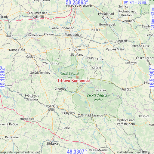
Trhová Kamenice GPS coordinates[2]
49° 47' 12.444" North, 15° 48' 57.384" East
| Map corner | latitude | longitude |
|---|---|---|
| Upper-left | 50.23863°, | 15.11282° |
| Center: | 49.78679°, | 15.81594° |
| Lower-right: | 49.3307°, | 16.51907° |
| Map W x H: | 101×101 km | = 62.8×62.8mi |
| max Lat: | 51.01104° ⇑48.9% North |
| Trhová Kamenice: | 49.78679° |
| min Lat: | ⇓51.1% South 48.60378° |
| min Long | Trhová Kamenic | max Long |
| 12.17577° | 15.81594° | 18.82683° |
| W 52%⇐ | ⇒48% E |
Elevation
Elevation of Trhová Kamenice is 531 m = 1742 ft, and this is 179 m = 587 ft above average elevation for this country.
| Max E: |
901 m = 2956 ft | 9.7% |
| Trhová Kamenice | 531 m 1742 ft | |
| Avg. | 352 m = 1155 ft | |
Min E: |
136 m = 446 ft | 90.3% |
See also: Czech Republic elevation on elevation.city.
Geographical zone
Trhová Kamenice is located in North temperate zone (between Tropic of Cancer and the Arctic Circle). Distance of this North polar circle is 1865.4 km =1159.1 mi to North.| Distance of | km | miles | from Trhová Kamenice |
|---|---|---|---|
| North Pole | 4471.3 | 2778.3 | to North |
| Arctic Circle | 1865.4 | 1159.1 | to North |
| Tropic Cancer | 2929.9 | 1820.6 | to South |
| Equator | 5535.8 | 3439.8 | to South |


Nearby cities:
15 places around Trhová Kamenice: (largest is in red/bold)
• Bojanov
10 km =6.2 mi,  307°
307°
• Chotěboř
12.8 km =8 mi,  234°
234°
• Dolní Holetín
8.1 km =5 mi,  77°
77°
• Hlinsko
7.1 km =4.4 mi,  112°
112°
• Kameničky
12.7 km =7.9 mi,  116°
116°
• Křížová
11.2 km =7 mi,  166°
166°
• Libice nad Doubravou
9.3 km =5.8 mi,  239°
239°
• Lukavice
11.5 km =7.1 mi,  8°
8°
• Maleč
10.1 km =6.3 mi,  260°
260°
• Miřetice
7.8 km =4.8 mi,  39°
39°
• Nasavrky
6.5 km =4 mi,  352°
352°
• Prosetín
11.4 km =7.1 mi,  63°
63°
• Rohozná
2.2 km =1.4 mi,  355°
355°
• Vojnův Městec
12.7 km =7.9 mi,  159°
159°
• Včelákov
6 km =3.7 mi, 55°
Sources, notices
• [Note1] Compared only with cities in Czech Republic existing in our database
• [Src1] Map data: © OpenStreetMap contributors (CC-BY-SA)
• [Src2] Other city data from geonames.org with taken over terms of usage.
• [Src3] Geographical zone / Annual Mean Temperature by Robert A. Rohde @ Wikipedia
