Třešť geodata
Třešť (Vysočina) is a populated place; located in Czech Republic in Europe/Prague (GMT+2) time zone. With population of 5,979 people, there are 232 cities with bigger population in this country. Compared to other cities in Czech Republic, 77% of cities are located further ↑North; 53.4% of cities are located further →East and 91.9% of cities have lower elevation than Třešť. Note1


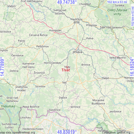
Třešť GPS coordinates[2]
49° 17' 27.312" North, 15° 28' 55.596" East
| Map corner | latitude | longitude |
|---|---|---|
| Upper-left | 49.74738°, | 14.77899° |
| Center: | 49.29092°, | 15.48211° |
| Lower-right: | 48.83019°, | 16.18524° |
| Map W x H: | 102×102 km | = 63.4×63.4mi |
| max Lat: | 51.01104° ⇑77% North |
| Třešť: | 49.29092° |
| min Lat: | ⇓23% South 48.60378° |
| min Long | Třešť | max Long |
| 12.17577° | 15.48211° | 18.82683° |
| W 46.6%⇐ | ⇒53.4% E |
Elevation
Elevation of Třešť is 550 m = 1804 ft, and this is 198 m = 650 ft above average elevation for this country.
| Max E: |
901 m = 2956 ft | 8.1% |
| Třešť | 550 m 1804 ft | |
| Avg. | 352 m = 1155 ft | |
Min E: |
136 m = 446 ft | 91.9% |
See also: Czech Republic elevation on elevation.city.
Geographical zone
Třešť is located in North temperate zone (between Tropic of Cancer and the Arctic Circle). Distance of this North polar circle is 1920.5 km =1193.3 mi to North.| Distance of | km | miles | from Třešť |
|---|---|---|---|
| North Pole | 4526.4 | 2812.6 | to North |
| Arctic Circle | 1920.5 | 1193.3 | to North |
| Tropic Cancer | 2874.7 | 1786.3 | to South |
| Equator | 5480.6 | 3405.5 | to South |


Nearby cities:
15 places around Třešť: (largest is in red/bold)
• Batelov
6.9 km =4.3 mi,  292°
292°
• Brtnice
14.2 km =8.8 mi,  82°
82°
• Dolní Cerekev
6.2 km =3.9 mi,  342°
342°
• Hodice
2.3 km =1.4 mi,  183°
183°
• Horní Cerekev
11.7 km =7.3 mi, 286°
• Horní Dubenky
12.5 km =7.8 mi,  253°
253°
• Jihlava
14.1 km =8.8 mi,  34°
34°
• Kněžice
14 km =8.7 mi,  99°
99°
• Kostelec
7.9 km =4.9 mi,  4°
4°
• Krahulčí
13.1 km =8.1 mi,  201°
201°
• Mrákotín
13.7 km =8.5 mi,  214°
214°
• Nový Rychnov
13.3 km =8.3 mi,  320°
320°
• Stonařov
7.6 km =4.7 mi, 97°
• Telč
12.1 km =7.5 mi,  190°
190°
• Vyskytná nad Jihlavou
14.4 km =8.9 mi,  7°
7°
Sources, notices
• [Note1] Compared only with cities in Czech Republic existing in our database
• [Src1] Map data: © OpenStreetMap contributors (CC-BY-SA)
• [Src2] Other city data from geonames.org with taken over terms of usage.
• [Src3] Geographical zone / Annual Mean Temperature by Robert A. Rohde @ Wikipedia
