Jihlava geodata
Jihlava (Vysočina) is a seat of a first-order administrative division; located in Czech Republic in Europe/Prague (GMT+2) time zone. With population of 50,100 people, there are 21 cities with bigger population in this country. Compared to other cities in Czech Republic, 71.2% of cities are located further ↑North; 51.8% of cities are located further →East and 88.9% of cities have lower elevation than Jihlava. Note1


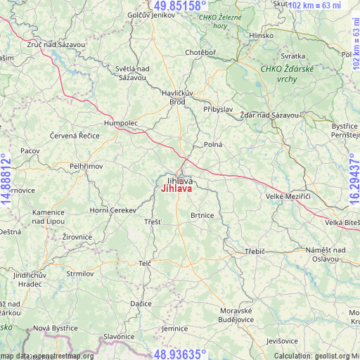
Jihlava GPS coordinates[2]
49° 23' 45.96" North, 15° 35' 28.464" East
| Map corner | latitude | longitude |
|---|---|---|
| Upper-left | 49.85158°, | 14.88812° |
| Center: | 49.3961°, | 15.59124° |
| Lower-right: | 48.93635°, | 16.29437° |
| Map W x H: | 101.8×101.8 km | = 63.3×63.3mi |
| max Lat: | 51.01104° ⇑71.2% North |
| Jihlava: | 49.3961° |
| min Lat: | ⇓28.8% South 48.60378° |
| min Long | Jihlava | max Long |
| 12.17577° | 15.59124° | 18.82683° |
| W 48.2%⇐ | ⇒51.8% E |
Elevation
Elevation of Jihlava is 523 m = 1716 ft, and this is 171 m = 561 ft above average elevation for this country.
| Max E: |
901 m = 2956 ft | 11.1% |
| Jihlava | 523 m 1716 ft | |
| Avg. | 352 m = 1155 ft | |
Min E: |
136 m = 446 ft | 88.9% |
See also: Jihlava elevation on elevation.city.
Geographical zone
Jihlava is located in North temperate zone (between Tropic of Cancer and the Arctic Circle). Distance of this North polar circle is 1908.8 km =1186.1 mi to North.| Distance of | km | miles | from Jihlava |
|---|---|---|---|
| North Pole | 4514.7 | 2805.3 | to North |
| Arctic Circle | 1908.8 | 1186.1 | to North |
| Tropic Cancer | 2886.4 | 1793.5 | to South |
| Equator | 5492.3 | 3412.8 | to South |


Nearby cities:
15 places around Jihlava: (largest is in red/bold)
• Brtnice
11.7 km =7.3 mi,  148°
148°
• Dobronín
10.1 km =6.3 mi,  24°
24°
• Dolní Cerekev
11.3 km =7 mi,  239°
239°
• Kamenice
14.1 km =8.8 mi,  103°
103°
• Kostelec
8.2 km =5.1 mi, 242°
• Luka nad Jihlavou
8.4 km =5.2 mi,  107°
107°
• Malý Beranov
3.4 km =2.1 mi,  89°
89°
• Polná
13.7 km =8.5 mi,  42°
42°
• Puklice
5.8 km =3.6 mi,  132°
132°
• Stonařov
12.7 km =7.9 mi,  181°
181°
• Třešť
14.1 km =8.8 mi,  214°
214°
• Velký Beranov
5.6 km =3.5 mi,  79°
79°
• Vyskytná nad Jihlavou
6.5 km =4 mi,  293°
293°
• Větrný Jeníkov
12 km =7.5 mi,  317°
317°
• Štoky
11.8 km =7.3 mi,  359°
359°
Sources, notices
• [Note1] Compared only with cities in Czech Republic existing in our database
• [Src1] Map data: © OpenStreetMap contributors (CC-BY-SA)
• [Src2] Other city data from geonames.org with taken over terms of usage.
• [Src3] Geographical zone / Annual Mean Temperature by Robert A. Rohde @ Wikipedia
