Tatobity geodata
Tatobity (Liberecký kraj) is a populated place; located in Czech Republic in Europe/Prague (GMT+2) time zone. With population of 530 people, there are 2381 cities with bigger population in this country. Compared to other cities in Czech Republic, 92.8% of cities are located further ↓South; 57.1% of cities are located further →East and 66.1% of cities have lower elevation than Tatobity. Note1


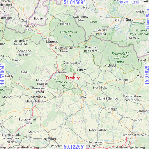
Tatobity GPS coordinates[2]
50° 34' 16.464" North, 15° 16' 23.376" East
| Map corner | latitude | longitude |
|---|---|---|
| Upper-left | 51.01569°, | 14.57004° |
| Center: | 50.57124°, | 15.27316° |
| Lower-right: | 50.12255°, | 15.97629° |
| Map W x H: | 99.3×99.3 km | = 61.7×61.7mi |
| max Lat: | 51.01104° ⇑7.2% North |
| Tatobity: | 50.57124° |
| min Lat: | ⇓92.8% South 48.60378° |
| min Long | Tatobity | max Long |
| 12.17577° | 15.27316° | 18.82683° |
| W 42.9%⇐ | ⇒57.1% E |
Elevation
Elevation of Tatobity is 400 m = 1312 ft, and this is 48 m = 157 ft above average elevation for this country.
| Max E: |
901 m = 2956 ft | 33.9% |
| Tatobity | 400 m 1312 ft | |
| Avg. | 352 m = 1155 ft | |
Min E: |
136 m = 446 ft | 66.1% |
See also: Czech Republic elevation on elevation.city.
Geographical zone
Tatobity is located in North temperate zone (between Tropic of Cancer and the Arctic Circle). Distance of this North polar circle is 1778.2 km =1104.9 mi to North.| Distance of | km | miles | from Tatobity |
|---|---|---|---|
| North Pole | 4384.1 | 2724.2 | to North |
| Arctic Circle | 1778.2 | 1104.9 | to North |
| Tropic Cancer | 3017.1 | 1874.7 | to South |
| Equator | 5623 | 3494 | to South |


Nearby cities:
15 places around Tatobity: (largest is in red/bold)
• Benešov u Semil
7.6 km =4.7 mi,  62°
62°
• Bozkov
8.9 km =5.5 mi,  30°
30°
• Chuchelna
3.9 km =2.4 mi, 29°
• Hrubá Skála
5.3 km =3.3 mi,  238°
238°
• Karlovice
4.8 km =3 mi,  257°
257°
• Koberovy
6.7 km =4.2 mi,  331°
331°
• Košťálov
9.2 km =5.7 mi,  89°
89°
• Libuň
8.3 km =5.2 mi,  167°
167°
• Lomnice nad Popelkou
8.4 km =5.2 mi,  122°
122°
• Rovensko pod Troskami
4.1 km =2.5 mi,  193°
193°
• Semily
5.6 km =3.5 mi,  52°
52°
• Slaná
4.1 km =2.5 mi,  75°
75°
• Stružinec
6.4 km =4 mi,  110°
110°
• Turnov
8.7 km =5.4 mi,  279°
279°
• Železný Brod
8.1 km =5 mi,  350°
350°
Sources, notices
• [Note1] Compared only with cities in Czech Republic existing in our database
• [Src1] Map data: © OpenStreetMap contributors (CC-BY-SA)
• [Src2] Other city data from geonames.org with taken over terms of usage.
• [Src3] Geographical zone / Annual Mean Temperature by Robert A. Rohde @ Wikipedia
