Karlovice geodata
Karlovice (Liberecký kraj) is a populated place; located in Czech Republic in Europe/Prague (GMT+2) time zone. With population of 694 people, there are 1854 cities with bigger population in this country. Compared to other cities in Czech Republic, 92.4% of cities are located further ↓South; 58.4% of cities are located further →East and 66.3% of cities have higher elevation than Karlovice. Note1


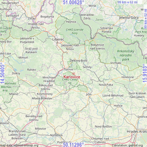
Karlovice GPS coordinates[2]
50° 33' 42.264" North, 15° 12' 25.812" East
| Map corner | latitude | longitude |
|---|---|---|
| Upper-left | 51.00628°, | 14.50405° |
| Center: | 50.56174°, | 15.20717° |
| Lower-right: | 50.11296°, | 15.9103° |
| Map W x H: | 99.3×99.3 km | = 61.7×61.7mi |
| max Lat: | 51.01104° ⇑7.6% North |
| Karlovice: | 50.56174° |
| min Lat: | ⇓92.4% South 48.60378° |
| min Long | Karlovice | max Long |
| 12.17577° | 15.20717° | 18.82683° |
| W 41.6%⇐ | ⇒58.4% E |
Elevation
Elevation of Karlovice is 268 m = 879 ft, and this is 84 m = 276 ft below average elevation for this country.
| Max E: |
901 m = 2956 ft | 66.3% |
| Avg. | 352 m = 1155 ft | |
| Karlovice | 268 m = 879 ft | |
Min E: |
136 m = 446 ft | 33.7% |
See also: Czech Republic elevation on elevation.city.
Geographical zone
Karlovice is located in North temperate zone (between Tropic of Cancer and the Arctic Circle). Distance of this North polar circle is 1779.2 km =1105.5 mi to North.| Distance of | km | miles | from Karlovice |
|---|---|---|---|
| North Pole | 4385.1 | 2724.8 | to North |
| Arctic Circle | 1779.2 | 1105.5 | to North |
| Tropic Cancer | 3016 | 1874.1 | to South |
| Equator | 5621.9 | 3493.3 | to South |


Nearby cities:
15 places around Karlovice: (largest is in red/bold)
• Chuchelna
8 km =5 mi,  55°
55°
• Hrubá Skála
1.7 km =1.1 mi,  175°
175°
• Jenišovice
8.9 km =5.5 mi,  325°
325°
• Koberovy
7.2 km =4.5 mi,  11°
11°
• Libuň
9.6 km =6 mi,  137°
137°
• Malá Skála
9.4 km =5.8 mi,  354°
354°
• Ohrazenice
7 km =4.3 mi,  304°
304°
• Přepeře
7.1 km =4.4 mi,  289°
289°
• Příšovice
8.9 km =5.5 mi,  281°
281°
• Rovensko pod Troskami
4.7 km =2.9 mi,  128°
128°
• Slaná
8.9 km =5.5 mi,  76°
76°
• Tatobity
4.8 km =3 mi, 77°
• Turnov
4.6 km =2.9 mi, 301°
• Železný Brod
9.6 km =6 mi,  20°
20°
• Žďár
9.2 km =5.7 mi,  257°
257°
Sources, notices
• [Note1] Compared only with cities in Czech Republic existing in our database
• [Src1] Map data: © OpenStreetMap contributors (CC-BY-SA)
• [Src2] Other city data from geonames.org with taken over terms of usage.
• [Src3] Geographical zone / Annual Mean Temperature by Robert A. Rohde @ Wikipedia
