Tachov geodata
Tachov (Plzeňský kraj) is a populated place; located in Czech Republic in Europe/Prague (GMT+2) time zone. With population of 12,640 people, there are 115 cities with bigger population in this country. Compared to other cities in Czech Republic, 51.8% of cities are located further ↓South; 98.9% of cities are located further →East and 83.1% of cities have lower elevation than Tachov. Note1


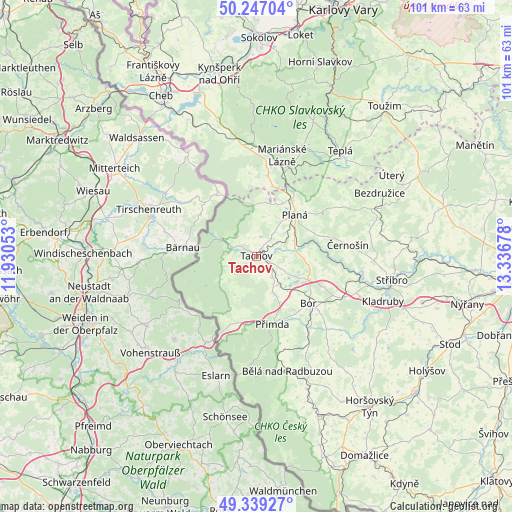
Tachov GPS coordinates[2]
49° 47' 43.008" North, 12° 38' 1.14" East
| Map corner | latitude | longitude |
|---|---|---|
| Upper-left | 50.24704°, | 11.93053° |
| Center: | 49.79528°, | 12.63365° |
| Lower-right: | 49.33927°, | 13.33678° |
| Map W x H: | 100.9×100.9 km | = 62.7×62.7mi |
| max Lat: | 51.01104° ⇑48.2% North |
| Tachov: | 49.79528° |
| min Lat: | ⇓51.8% South 48.60378° |
| min Long | Tachov | max Long |
| 12.17577° | 12.63365° | 18.82683° |
| W 1.1%⇐ | ⇒98.9% E |
Elevation
Elevation of Tachov is 483 m = 1585 ft, and this is 131 m = 430 ft above average elevation for this country.
| Max E: |
901 m = 2956 ft | 16.9% |
| Tachov | 483 m 1585 ft | |
| Avg. | 352 m = 1155 ft | |
Min E: |
136 m = 446 ft | 83.1% |
See also: Czech Republic elevation on elevation.city.
Geographical zone
Tachov is located in North temperate zone (between Tropic of Cancer and the Arctic Circle). Distance of this North polar circle is 1864.5 km =1158.5 mi to North.| Distance of | km | miles | from Tachov |
|---|---|---|---|
| North Pole | 4470.3 | 2777.7 | to North |
| Arctic Circle | 1864.5 | 1158.5 | to North |
| Tropic Cancer | 2930.8 | 1821.1 | to South |
| Equator | 5536.7 | 3440.3 | to South |


Nearby cities:
15 places around Tachov: (largest is in red/bold)
• Bor
13.8 km =8.6 mi,  132°
132°
• Bělá nad Radbuzou
23.5 km =14.6 mi,  165°
165°
• Chodová Planá
12.9 km =8 mi,  32°
32°
• Drmoul
16.1 km =10 mi,  8°
8°
• Halže
5.6 km =3.5 mi,  315°
315°
• Lázně Kynžvart
23.9 km =14.9 mi,  358°
358°
• Mariánské Lázně
19.4 km =12.1 mi, 14°
• Planá
11.3 km =7 mi,  44°
44°
• Přimda
13.7 km =8.5 mi, 167°
• Rozvadov
15.3 km =9.5 mi,  202°
202°
• Staré Sedliště
7.1 km =4.4 mi,  142°
142°
• Stráž
17.4 km =10.8 mi, 144°
• Tři Sekery
16.4 km =10.2 mi, 355°
• Velká Hleďsebe
18.6 km =11.6 mi, 7°
• Černošín
18.1 km =11.2 mi,  82°
82°
Sources, notices
• [Note1] Compared only with cities in Czech Republic existing in our database
• [Src1] Map data: © OpenStreetMap contributors (CC-BY-SA)
• [Src2] Other city data from geonames.org with taken over terms of usage.
• [Src3] Geographical zone / Annual Mean Temperature by Robert A. Rohde @ Wikipedia
