Černošín geodata
Černošín (Plzeňský kraj) is a populated place; located in Czech Republic in Europe/Prague (GMT+2) time zone. With population of 1,097 people, there are 1178 cities with bigger population in this country. Compared to other cities in Czech Republic, 52.7% of cities are located further ↓South; 97.1% of cities are located further →East and 85.5% of cities have lower elevation than Černošín. Note1


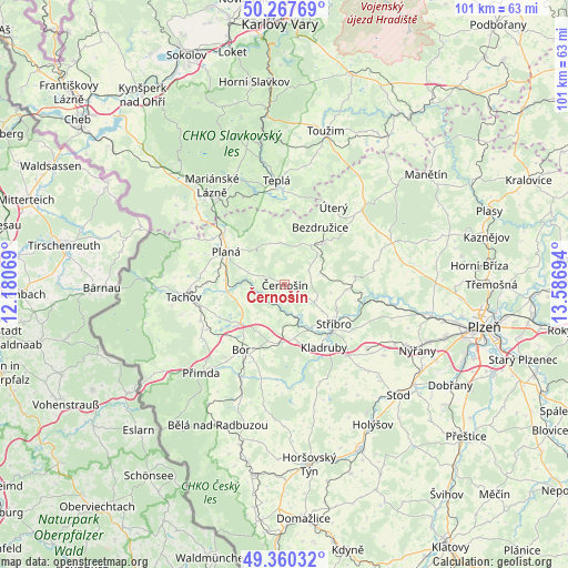
Černošín GPS coordinates[2]
49° 48' 58.068" North, 12° 53' 1.716" East
| Map corner | latitude | longitude |
|---|---|---|
| Upper-left | 50.26769°, | 12.18069° |
| Center: | 49.81613°, | 12.88381° |
| Lower-right: | 49.36032°, | 13.58694° |
| Map W x H: | 100.9×100.9 km | = 62.7×62.7mi |
| max Lat: | 51.01104° ⇑47.3% North |
| Černošín: | 49.81613° |
| min Lat: | ⇓52.7% South 48.60378° |
| min Long | Černošín | max Long |
| 12.17577° | 12.88381° | 18.82683° |
| W 2.9%⇐ | ⇒97.1% E |
Elevation
Elevation of Černošín is 498 m = 1634 ft, and this is 146 m = 479 ft above average elevation for this country.
| Max E: |
901 m = 2956 ft | 14.5% |
| Černošín | 498 m 1634 ft | |
| Avg. | 352 m = 1155 ft | |
Min E: |
136 m = 446 ft | 85.5% |
See also: Czech Republic elevation on elevation.city.
Geographical zone
Černošín is located in North temperate zone (between Tropic of Cancer and the Arctic Circle). Distance of this North polar circle is 1862.1 km =1157.1 mi to North.| Distance of | km | miles | from Černošín |
|---|---|---|---|
| North Pole | 4468 | 2776.3 | to North |
| Arctic Circle | 1862.1 | 1157.1 | to North |
| Tropic Cancer | 2933.1 | 1822.5 | to South |
| Equator | 5539 | 3441.8 | to South |


Nearby cities:
15 places around Černošín: (largest is in red/bold)
• Bezdružice
11.9 km =7.4 mi,  31°
31°
• Bor
14 km =8.7 mi,  213°
213°
• Chodová Planá
14 km =8.7 mi,  307°
307°
• Heřmanova Huť
19.8 km =12.3 mi,  127°
127°
• Kladruby
13.3 km =8.3 mi,  147°
147°
• Klášter
16.9 km =10.5 mi,  358°
358°
• Konstantinovy Lázně
9.9 km =6.2 mi,  43°
43°
• Kostelec
18.8 km =11.7 mi, 146°
• Město
18.3 km =11.4 mi, 355°
• Pernarec
15.9 km =9.9 mi,  79°
79°
• Planá
11.6 km =7.2 mi,  299°
299°
• Staré Sedliště
15.8 km =9.8 mi,  239°
239°
• Stráž
18.1 km =11.2 mi, 205°
• Stříbro
10.5 km =6.5 mi, 129°
• Tachov
18.1 km =11.2 mi,  262°
262°
Sources, notices
• [Note1] Compared only with cities in Czech Republic existing in our database
• [Src1] Map data: © OpenStreetMap contributors (CC-BY-SA)
• [Src2] Other city data from geonames.org with taken over terms of usage.
• [Src3] Geographical zone / Annual Mean Temperature by Robert A. Rohde @ Wikipedia
