Svor geodata
Svor (Liberecký kraj) is a populated place; located in Czech Republic in Europe/Prague (GMT+2) time zone. With population of 637 people, there are 2026 cities with bigger population in this country. Compared to other cities in Czech Republic, 98.6% of cities are located further ↓South; 69% of cities are located further →East and 73% of cities have lower elevation than Svor. Note1


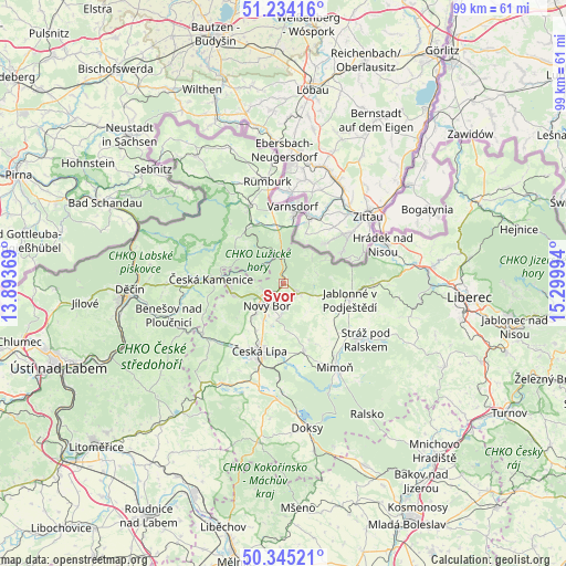
Svor GPS coordinates[2]
50° 47' 30.48" North, 14° 35' 48.516" East
| Map corner | latitude | longitude |
|---|---|---|
| Upper-left | 51.23416°, | 13.89369° |
| Center: | 50.7918°, | 14.59681° |
| Lower-right: | 50.34521°, | 15.29994° |
| Map W x H: | 98.8×98.8 km | = 61.4×61.4mi |
| max Lat: | 51.01104° ⇑1.4% North |
| Svor: | 50.7918° |
| min Lat: | ⇓98.6% South 48.60378° |
| min Long | Svor | max Long |
| 12.17577° | 14.59681° | 18.82683° |
| W 31%⇐ | ⇒69% E |
Elevation
Elevation of Svor is 429 m = 1407 ft, and this is 77 m = 253 ft above average elevation for this country.
| Max E: |
901 m = 2956 ft | 27% |
| Svor | 429 m 1407 ft | |
| Avg. | 352 m = 1155 ft | |
Min E: |
136 m = 446 ft | 73% |
See also: Czech Republic elevation on elevation.city.
Geographical zone
Svor is located in North temperate zone (between Tropic of Cancer and the Arctic Circle). Distance of this North polar circle is 1753.7 km =1089.7 mi to North.| Distance of | km | miles | from Svor |
|---|---|---|---|
| North Pole | 4359.5 | 2708.9 | to North |
| Arctic Circle | 1753.7 | 1089.7 | to North |
| Tropic Cancer | 3041.6 | 1890 | to South |
| Equator | 5647.5 | 3509.2 | to South |


Nearby cities:
15 places around Svor: (largest is in red/bold)
• Brniště
10.2 km =6.3 mi,  132°
132°
• Chřibská
11 km =6.8 mi,  314°
314°
• Cvikov
3 km =1.9 mi,  123°
123°
• Dolní Podluží
9.8 km =6.1 mi,  359°
359°
• Horní Podluží
10.6 km =6.6 mi,  340°
340°
• Jablonné v Podještědí
11.9 km =7.4 mi,  104°
104°
• Jiřetín pod Jedlovou
9.3 km =5.8 mi,  350°
350°
• Kamenický Šenov
8.9 km =5.5 mi,  256°
256°
• Nový Bor
4.8 km =3 mi,  217°
217°
• Nový Oldřichov
11.3 km =7 mi,  254°
254°
• Rybniště
11.4 km =7.1 mi,  329°
329°
• Volfartice
12.2 km =7.6 mi,  235°
235°
• Zákupy
12.4 km =7.7 mi,  164°
164°
• Česká Kamenice
12.6 km =7.8 mi,  273°
273°
• Česká Lípa
12.5 km =7.8 mi,  199°
199°
Sources, notices
• [Note1] Compared only with cities in Czech Republic existing in our database
• [Src1] Map data: © OpenStreetMap contributors (CC-BY-SA)
• [Src2] Other city data from geonames.org with taken over terms of usage.
• [Src3] Geographical zone / Annual Mean Temperature by Robert A. Rohde @ Wikipedia
