Jiřetín pod Jedlovou geodata
Jiřetín pod Jedlovou (Ústecký kraj) is a populated place; located in Czech Republic in Europe/Prague (GMT+2) time zone. With population of 587 people, there are 2168 cities with bigger population in this country. Compared to other cities in Czech Republic, 99.1% of cities are located further ↓South; 69.7% of cities are located further →East and 79.9% of cities have lower elevation than Jiřetín pod Jedlovou. Note1
Administrative division(s):
- Level 1: Ústecký kraj
- Level 2: Okres Děčín
- Level 3: Jiřetín pod Jedlovou


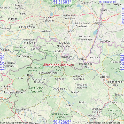
Jiřetín pod Jedlovou GPS coordinates[2]
50° 52' 28.02" North, 14° 34' 30.288" East
| Map corner | latitude | longitude |
|---|---|---|
| Upper-left | 51.31603°, | 13.87196° |
| Center: | 50.87445°, | 14.57508° |
| Lower-right: | 50.42865°, | 15.27821° |
| Map W x H: | 98.7×98.7 km | = 61.3×61.3mi |
| max Lat: | 51.01104° ⇑0.9% North |
| Jiřetín pod Jedlovou: | 50.87445° |
| min Lat: | ⇓99.1% South 48.60378° |
| min Long | Jiřetín pod J | max Long |
| 12.17577° | 14.57508° | 18.82683° |
| W 30.3%⇐ | ⇒69.7% E |
Elevation
Elevation of Jiřetín pod Jedlovou is 464 m = 1522 ft, and this is 112 m = 367 ft above average elevation for this country.
| Max E: |
901 m = 2956 ft | 20.1% |
| Jiřetín pod Jedlovou | 464 m 1522 ft | |
| Avg. | 352 m = 1155 ft | |
Min E: |
136 m = 446 ft | 79.9% |
See also: Czech Republic elevation on elevation.city.
Geographical zone
Jiřetín pod Jedlovou is located in North temperate zone (between Tropic of Cancer and the Arctic Circle). Distance of this North polar circle is 1744.5 km =1084 mi to North.| Distance of | km | miles | from Jiřetín pod Jedlovou |
|---|---|---|---|
| North Pole | 4350.4 | 2703.2 | to North |
| Arctic Circle | 1744.5 | 1084 | to North |
| Tropic Cancer | 3050.8 | 1895.7 | to South |
| Equator | 5656.7 | 3514.9 | to South |


Nearby cities:
15 places around Jiřetín pod Jedlovou: (largest is in red/bold)
• Chřibská
6.5 km =4 mi,  256°
256°
• Cvikov
11.6 km =7.2 mi,  159°
159°
• Dolní Podluží
1.5 km =0.9 mi,  66°
66°
• Horní Podluží
2.2 km =1.4 mi,  290°
290°
• Jiříkov
13.4 km =8.3 mi,  358°
358°
• Kamenický Šenov
13.3 km =8.3 mi,  212°
212°
• Krásná Lípa
6.3 km =3.9 mi,  313°
313°
• Nový Bor
13.1 km =8.1 mi,  186°
186°
• Nový Oldřichov
15.3 km =9.5 mi,  217°
217°
• Rumburk
8.7 km =5.4 mi,  351°
351°
• Rybniště
4.3 km =2.7 mi,  278°
278°
• Staré Křečany
10.1 km =6.3 mi,  326°
326°
• Svor
9.3 km =5.8 mi,  170°
170°
• Varnsdorf
5.1 km =3.2 mi,  36°
36°
• Česká Kamenice
14 km =8.7 mi,  232°
232°
Sources, notices
• [Note1] Compared only with cities in Czech Republic existing in our database
• [Src1] Map data: © OpenStreetMap contributors (CC-BY-SA)
• [Src2] Other city data from geonames.org with taken over terms of usage.
• [Src3] Geographical zone / Annual Mean Temperature by Robert A. Rohde @ Wikipedia
