Střítež nad Ludinou geodata
Střítež nad Ludinou (Olomoucký) is a populated place; located in Czech Republic in Europe/Prague (GMT+2) time zone. With population of 853 people, there are 1505 cities with bigger population in this country. Compared to other cities in Czech Republic, 59.2% of cities are located further ↑North; 88.9% of cities are located further ←West and 52.4% of cities have lower elevation than Střítež nad Ludinou. Note1


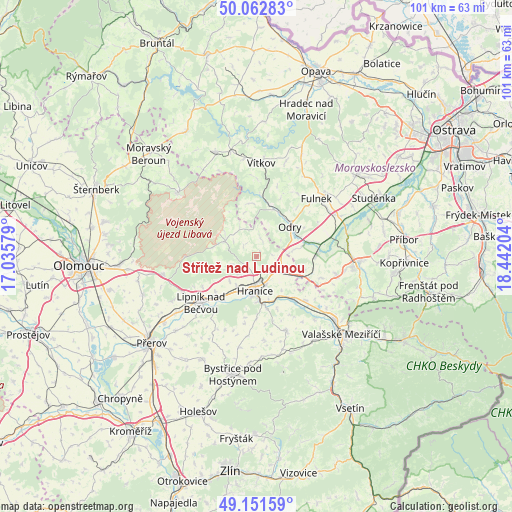
Střítež nad Ludinou GPS coordinates[2]
49° 36' 33.624" North, 17° 44' 20.076" East
| Map corner | latitude | longitude |
|---|---|---|
| Upper-left | 50.06283°, | 17.03579° |
| Center: | 49.60934°, | 17.73891° |
| Lower-right: | 49.15159°, | 18.44204° |
| Map W x H: | 101.3×101.3 km | = 62.9×62.9mi |
| max Lat: | 51.01104° ⇑59.2% North |
| Střítež nad Ludinou: | 49.60934° |
| min Lat: | ⇓40.8% South 48.60378° |
| min Long | Střítež nad | max Long |
| 12.17577° | 17.73891° | 18.82683° |
| W 88.9%⇐ | ⇒11.1% E |
Elevation
Elevation of Střítež nad Ludinou is 347 m = 1138 ft, and this is 5 m = 16 ft below average elevation for this country.
| Max E: |
901 m = 2956 ft | 47.6% |
| Avg. | 352 m = 1155 ft | |
| Střítež nad Ludinou | 347 m = 1138 ft | |
Min E: |
136 m = 446 ft | 52.4% |
See also: Czech Republic elevation on elevation.city.
Geographical zone
Střítež nad Ludinou is located in North temperate zone (between Tropic of Cancer and the Arctic Circle). Distance of this North polar circle is 1885.1 km =1171.3 mi to North.| Distance of | km | miles | from Střítež nad Ludinou |
|---|---|---|---|
| North Pole | 4491 | 2790.6 | to North |
| Arctic Circle | 1885.1 | 1171.3 | to North |
| Tropic Cancer | 2910.1 | 1808.3 | to South |
| Equator | 5516 | 3427.5 | to South |


Nearby cities:
15 places around Střítež nad Ludinou: (largest is in red/bold)
• Bělotín
5.3 km =3.3 mi,  112°
112°
• Hranice
6.8 km =4.2 mi,  182°
182°
• Hustopeče Nad Bečvou
12.9 km =8 mi,  132°
132°
• Jakubčovice nad Odrou
10.2 km =6.3 mi,  20°
20°
• Jeseník nad Odrou
12 km =7.5 mi,  88°
88°
• Jezernice
10.7 km =6.6 mi,  230°
230°
• Mankovice
10.6 km =6.6 mi,  72°
72°
• Odry
8.9 km =5.5 mi,  48°
48°
• Opatovice
12.2 km =7.6 mi, 179°
• Potštát
7 km =4.3 mi,  296°
296°
• Skalička
11.2 km =7 mi,  158°
158°
• Spálov
10.6 km =6.6 mi,  353°
353°
• Týn nad Bečvou
13.5 km =8.4 mi,  220°
220°
• Ústí
10.5 km =6.5 mi,  169°
169°
• Černotín
8.9 km =5.5 mi, 164°
Sources, notices
• [Note1] Compared only with cities in Czech Republic existing in our database
• [Src1] Map data: © OpenStreetMap contributors (CC-BY-SA)
• [Src2] Other city data from geonames.org with taken over terms of usage.
• [Src3] Geographical zone / Annual Mean Temperature by Robert A. Rohde @ Wikipedia
