Skalička geodata
Skalička (Olomoucký) is a populated place; located in Czech Republic in Europe/Prague (GMT+2) time zone. With population of 545 people, there are 2331 cities with bigger population in this country. Compared to other cities in Czech Republic, 65.1% of cities are located further ↑North; 89.9% of cities are located further ←West and 65.6% of cities have higher elevation than Skalička. Note1


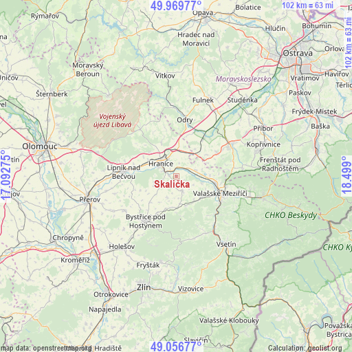
Skalička GPS coordinates[2]
49° 30' 55.44" North, 17° 47' 45.132" East
| Map corner | latitude | longitude |
|---|---|---|
| Upper-left | 49.96977°, | 17.09275° |
| Center: | 49.5154°, | 17.79587° |
| Lower-right: | 49.05677°, | 18.499° |
| Map W x H: | 101.5×101.5 km | = 63.1×63.1mi |
| max Lat: | 51.01104° ⇑65.1% North |
| Skalička: | 49.5154° |
| min Lat: | ⇓34.9% South 48.60378° |
| min Long | Skalička | max Long |
| 12.17577° | 17.79587° | 18.82683° |
| W 89.9%⇐ | ⇒10.1% E |
Elevation
Elevation of Skalička is 271 m = 889 ft, and this is 81 m = 266 ft below average elevation for this country.
| Max E: |
901 m = 2956 ft | 65.6% |
| Avg. | 352 m = 1155 ft | |
| Skalička | 271 m = 889 ft | |
Min E: |
136 m = 446 ft | 34.4% |
See also: Czech Republic elevation on elevation.city.
Geographical zone
Skalička is located in North temperate zone (between Tropic of Cancer and the Arctic Circle). Distance of this North polar circle is 1895.6 km =1177.9 mi to North.| Distance of | km | miles | from Skalička |
|---|---|---|---|
| North Pole | 4501.5 | 2797.1 | to North |
| Arctic Circle | 1895.6 | 1177.9 | to North |
| Tropic Cancer | 2899.7 | 1801.8 | to South |
| Equator | 5505.6 | 3421 | to South |


Nearby cities:
15 places around Skalička: (largest is in red/bold)
• Branky
9.3 km =5.8 mi,  130°
130°
• Bělotín
8.5 km =5.3 mi,  5°
5°
• Choryně
7.7 km =4.8 mi,  106°
106°
• Hranice
5.7 km =3.5 mi,  309°
309°
• Hustopeče Nad Bečvou
5.6 km =3.5 mi,  72°
72°
• Kelč
4.3 km =2.7 mi,  161°
161°
• Kunovice
8 km =5 mi,  172°
172°
• Lešná
9.7 km =6 mi,  86°
86°
• Loučka
8.9 km =5.5 mi, 162°
• Opatovice
4.5 km =2.8 mi,  246°
246°
• Podhradní Lhota
10.5 km =6.5 mi,  180°
180°
• Police
8.3 km =5.2 mi,  141°
141°
• Všechovice
6.5 km =4 mi,  204°
204°
• Ústí
2.1 km =1.3 mi,  274°
274°
• Černotín
2.5 km =1.6 mi,  316°
316°
Sources, notices
• [Note1] Compared only with cities in Czech Republic existing in our database
• [Src1] Map data: © OpenStreetMap contributors (CC-BY-SA)
• [Src2] Other city data from geonames.org with taken over terms of usage.
• [Src3] Geographical zone / Annual Mean Temperature by Robert A. Rohde @ Wikipedia
