Rozseč nad Kunštátem geodata
Rozseč nad Kunštátem (South Moravian) is a populated place; located in Czech Republic in Europe/Prague (GMT+2) time zone. With population of 506 people, there are 2479 cities with bigger population in this country. Compared to other cities in Czech Republic, 64.6% of cities are located further ↑North; 63.7% of cities are located further ←West and 97.3% of cities have lower elevation than Rozseč nad Kunštátem. Note1
Administrative division(s):
- Level 1: South Moravian
- Level 2: Okres Blansko
- Level 3: Rozseč nad Kunštátem


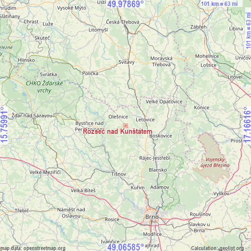
Rozseč nad Kunštátem GPS coordinates[2]
49° 31' 27.84" North, 16° 27' 46.908" East
| Map corner | latitude | longitude |
|---|---|---|
| Upper-left | 49.97869°, | 15.75991° |
| Center: | 49.5244°, | 16.46303° |
| Lower-right: | 49.06585°, | 17.16616° |
| Map W x H: | 101.5×101.5 km | = 63.1×63.1mi |
| max Lat: | 51.01104° ⇑64.6% North |
| Rozseč nad Kunštátem: | 49.5244° |
| min Lat: | ⇓35.4% South 48.60378° |
| min Long | Rozseč nad Kun | max Long |
| 12.17577° | 16.46303° | 18.82683° |
| W 63.7%⇐ | ⇒36.3% E |
Elevation
Elevation of Rozseč nad Kunštátem is 628 m = 2060 ft, and this is 276 m = 906 ft above average elevation for this country.
| Max E: |
901 m = 2956 ft | 2.7% |
| Rozseč nad Kunštátem | 628 m 2060 ft | |
| Avg. | 352 m = 1155 ft | |
Min E: |
136 m = 446 ft | 97.3% |
See also: Czech Republic elevation on elevation.city.
Geographical zone
Rozseč nad Kunštátem is located in North temperate zone (between Tropic of Cancer and the Arctic Circle). Distance of this North polar circle is 1894.6 km =1177.2 mi to North.| Distance of | km | miles | from Rozseč nad Kunštátem |
|---|---|---|---|
| North Pole | 4500.5 | 2796.5 | to North |
| Arctic Circle | 1894.6 | 1177.2 | to North |
| Tropic Cancer | 2900.7 | 1802.4 | to South |
| Equator | 5506.6 | 3421.6 | to South |


Nearby cities:
15 places around Rozseč nad Kunštátem: (largest is in red/bold)
• Brněnec
12.2 km =7.6 mi,  20°
20°
• Doubravník
13.7 km =8.5 mi,  215°
215°
• Drnovice
8.4 km =5.2 mi,  136°
136°
• Kunštát
4.4 km =2.7 mi,  117°
117°
• Křetín
5.2 km =3.2 mi,  34°
34°
• Letovice
8.4 km =5.2 mi,  72°
72°
• Lomnice
13.8 km =8.6 mi,  195°
195°
• Lysice
9.7 km =6 mi,  146°
146°
• Nedvědice
12 km =7.5 mi,  231°
231°
• Olešnice
4.7 km =2.9 mi,  321°
321°
• Rovečné
9.4 km =5.8 mi,  309°
309°
• Sebranice
9.6 km =6 mi,  109°
109°
• Skalice nad Svitavou
11.2 km =7 mi, 115°
• Svitávka
10.1 km =6.3 mi,  104°
104°
• Vír
10.7 km =6.6 mi,  290°
290°
Sources, notices
• [Note1] Compared only with cities in Czech Republic existing in our database
• [Src1] Map data: © OpenStreetMap contributors (CC-BY-SA)
• [Src2] Other city data from geonames.org with taken over terms of usage.
• [Src3] Geographical zone / Annual Mean Temperature by Robert A. Rohde @ Wikipedia
