Brněnec geodata
Brněnec (Pardubický) is a populated place; located in Czech Republic in Europe/Prague (GMT+2) time zone. With population of 1,405 people, there are 908 cities with bigger population in this country. Compared to other cities in Czech Republic, 58.4% of cities are located further ↑North; 65.1% of cities are located further ←West and 60.2% of cities have lower elevation than Brněnec. Note1


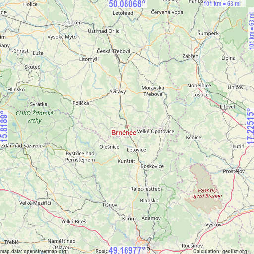
Brněnec GPS coordinates[2]
49° 37' 38.46" North, 16° 31' 19.272" East
| Map corner | latitude | longitude |
|---|---|---|
| Upper-left | 50.08068°, | 15.8189° |
| Center: | 49.62735°, | 16.52202° |
| Lower-right: | 49.16977°, | 17.22515° |
| Map W x H: | 101.3×101.3 km | = 62.9×62.9mi |
| max Lat: | 51.01104° ⇑58.4% North |
| Brněnec: | 49.62735° |
| min Lat: | ⇓41.6% South 48.60378° |
| min Long | Brněnec | max Long |
| 12.17577° | 16.52202° | 18.82683° |
| W 65.1%⇐ | ⇒34.9% E |
Elevation
Elevation of Brněnec is 377 m = 1237 ft, and this is 25 m = 82 ft above average elevation for this country.
| Max E: |
901 m = 2956 ft | 39.8% |
| Brněnec | 377 m 1237 ft | |
| Avg. | 352 m = 1155 ft | |
Min E: |
136 m = 446 ft | 60.2% |
See also: Czech Republic elevation on elevation.city.
Geographical zone
Brněnec is located in North temperate zone (between Tropic of Cancer and the Arctic Circle). Distance of this North polar circle is 1883.1 km =1170.1 mi to North.| Distance of | km | miles | from Brněnec |
|---|---|---|---|
| North Pole | 4489 | 2789.3 | to North |
| Arctic Circle | 1883.1 | 1170.1 | to North |
| Tropic Cancer | 2912.1 | 1809.5 | to South |
| Equator | 5518 | 3428.7 | to South |


Nearby cities:
15 places around Brněnec: (largest is in red/bold)
• Bystré
12.6 km =7.8 mi,  270°
270°
• Březová nad Svitavou
1.9 km =1.2 mi,  351°
351°
• Dlouhá Loučka
11.9 km =7.4 mi,  46°
46°
• Hradec nad Svitavou
9.8 km =6.1 mi,  342°
342°
• Jevíčko
13.6 km =8.5 mi,  87°
87°
• Kunštát
13.4 km =8.3 mi,  181°
181°
• Křetín
7.3 km =4.5 mi,  190°
190°
• Letovice
9.7 km =6 mi,  157°
157°
• Olešnice
10.6 km =6.6 mi,  222°
222°
• Radiměř
9.8 km =6.1 mi,  323°
323°
• Rohozná
8.7 km =5.4 mi,  289°
289°
• Rovečné
12.8 km =8 mi,  244°
244°
• Rozseč nad Kunštátem
12.2 km =7.6 mi,  200°
200°
• Vanovice
12.4 km =7.7 mi,  122°
122°
• Velké Opatovice
11.5 km =7.1 mi,  98°
98°
Sources, notices
• [Note1] Compared only with cities in Czech Republic existing in our database
• [Src1] Map data: © OpenStreetMap contributors (CC-BY-SA)
• [Src2] Other city data from geonames.org with taken over terms of usage.
• [Src3] Geographical zone / Annual Mean Temperature by Robert A. Rohde @ Wikipedia
