Písařov geodata
Písařov (Olomoucký) is a populated place; located in Czech Republic in Europe/Prague (GMT+2) time zone. With population of 703 people, there are 1827 cities with bigger population in this country. Compared to other cities in Czech Republic, 66.3% of cities are located further ↓South; 71.2% of cities are located further ←West and 91.5% of cities have lower elevation than Písařov. Note1


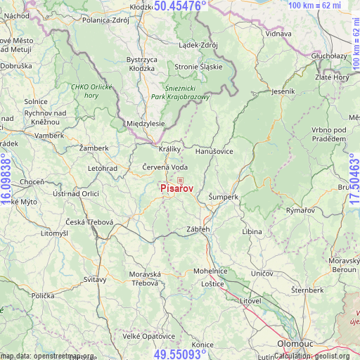
Písařov GPS coordinates[2]
50° 0' 17.892" North, 16° 48' 5.4" East
| Map corner | latitude | longitude |
|---|---|---|
| Upper-left | 50.45476°, | 16.09838° |
| Center: | 50.00497°, | 16.8015° |
| Lower-right: | 49.55093°, | 17.50463° |
| Map W x H: | 100.5×100.5 km | = 62.4×62.4mi |
| max Lat: | 51.01104° ⇑33.7% North |
| Písařov: | 50.00497° |
| min Lat: | ⇓66.3% South 48.60378° |
| min Long | Písařov | max Long |
| 12.17577° | 16.8015° | 18.82683° |
| W 71.2%⇐ | ⇒28.8% E |
Elevation
Elevation of Písařov is 544 m = 1785 ft, and this is 192 m = 630 ft above average elevation for this country.
| Max E: |
901 m = 2956 ft | 8.5% |
| Písařov | 544 m 1785 ft | |
| Avg. | 352 m = 1155 ft | |
Min E: |
136 m = 446 ft | 91.5% |
See also: Czech Republic elevation on elevation.city.
Geographical zone
Písařov is located in North temperate zone (between Tropic of Cancer and the Arctic Circle). Distance of this North polar circle is 1841.1 km =1144 mi to North.| Distance of | km | miles | from Písařov |
|---|---|---|---|
| North Pole | 4447 | 2763.2 | to North |
| Arctic Circle | 1841.1 | 1144 | to North |
| Tropic Cancer | 2954.1 | 1835.6 | to South |
| Equator | 5560 | 3454.8 | to South |


Nearby cities:
15 places around Písařov: (largest is in red/bold)
• Bludov
11.5 km =7.1 mi,  128°
128°
• Bohutín
8.1 km =5 mi, 134°
• Bratrušov
10.6 km =6.6 mi,  87°
87°
• Chromeč
10.3 km =6.4 mi,  140°
140°
• Dolní Bohdíkov
7.4 km =4.6 mi, 85°
• Jamné nad Orlicí
12.6 km =7.8 mi,  287°
287°
• Jedlí
8.2 km =5.1 mi,  183°
183°
• Králíky
9.2 km =5.7 mi,  341°
341°
• Malá Morava
10.3 km =6.4 mi,  10°
10°
• Olšany
6 km =3.7 mi, 137°
• Rovensko
12.1 km =7.5 mi,  153°
153°
• Ruda nad Moravou
6.1 km =3.8 mi,  116°
116°
• Výprachtice
10 km =6.2 mi,  258°
258°
• Červená Voda
5.8 km =3.6 mi,  313°
313°
• Štíty
5.5 km =3.4 mi,  207°
207°
Sources, notices
• [Note1] Compared only with cities in Czech Republic existing in our database
• [Src1] Map data: © OpenStreetMap contributors (CC-BY-SA)
• [Src2] Other city data from geonames.org with taken over terms of usage.
• [Src3] Geographical zone / Annual Mean Temperature by Robert A. Rohde @ Wikipedia
