Olšany geodata
Olšany (Olomoucký) is a populated place; located in Czech Republic in Europe/Prague (GMT+2) time zone. With population of 1,108 people, there are 1171 cities with bigger population in this country. Compared to other cities in Czech Republic, 63.5% of cities are located further ↓South; 72.4% of cities are located further ←West and 53.5% of cities have higher elevation than Olšany. Note1


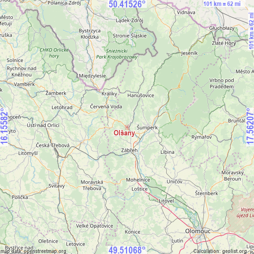
Olšany GPS coordinates[2]
49° 57' 54.324" North, 16° 51' 32.184" East
| Map corner | latitude | longitude |
|---|---|---|
| Upper-left | 50.41526°, | 16.15582° |
| Center: | 49.96509°, | 16.85894° |
| Lower-right: | 49.51068°, | 17.56207° |
| Map W x H: | 100.6×100.6 km | = 62.5×62.5mi |
| max Lat: | 51.01104° ⇑36.5% North |
| Olšany: | 49.96509° |
| min Lat: | ⇓63.5% South 48.60378° |
| min Long | Olšany | max Long |
| 12.17577° | 16.85894° | 18.82683° |
| W 72.4%⇐ | ⇒27.6% E |
Elevation
Elevation of Olšany is 320 m = 1050 ft, and this is 32 m = 105 ft below average elevation for this country.
| Max E: |
901 m = 2956 ft | 53.5% |
| Avg. | 352 m = 1155 ft | |
| Olšany | 320 m = 1050 ft | |
Min E: |
136 m = 446 ft | 46.5% |
See also: Czech Republic elevation on elevation.city.
Geographical zone
Olšany is located in North temperate zone (between Tropic of Cancer and the Arctic Circle). Distance of this North polar circle is 1845.6 km =1146.8 mi to North.| Distance of | km | miles | from Olšany |
|---|---|---|---|
| North Pole | 4451.5 | 2766 | to North |
| Arctic Circle | 1845.6 | 1146.8 | to North |
| Tropic Cancer | 2949.7 | 1832.9 | to South |
| Equator | 5555.6 | 3452.1 | to South |


Nearby cities:
15 places around Olšany: (largest is in red/bold)
• Bludov
5.7 km =3.5 mi,  118°
118°
• Bohutín
2.1 km =1.3 mi,  128°
128°
• Bratrušov
8.1 km =5 mi,  52°
52°
• Chromeč
4.3 km =2.7 mi,  144°
144°
• Dolní Bohdíkov
6 km =3.7 mi,  33°
33°
• Dolní Studénky
8.7 km =5.4 mi,  112°
112°
• Jedlí
5.9 km =3.7 mi,  230°
230°
• Postřelmov
7.4 km =4.6 mi,  149°
149°
• Písařov
6 km =3.7 mi,  317°
317°
• Rovensko
6.5 km =4 mi,  169°
169°
• Ruda nad Moravou
2.2 km =1.4 mi,  37°
37°
• Sudkov
8 km =5 mi, 129°
• Zábřeh
9.2 km =5.7 mi, 174°
• Štíty
6.7 km =4.2 mi,  266°
266°
• Šumperk
8 km =5 mi,  89°
89°
Sources, notices
• [Note1] Compared only with cities in Czech Republic existing in our database
• [Src1] Map data: © OpenStreetMap contributors (CC-BY-SA)
• [Src2] Other city data from geonames.org with taken over terms of usage.
• [Src3] Geographical zone / Annual Mean Temperature by Robert A. Rohde @ Wikipedia
