Kotvrdovice geodata
Kotvrdovice (South Moravian) is a populated place; located in Czech Republic in Europe/Prague (GMT+2) time zone. With population of 841 people, there are 1525 cities with bigger population in this country. Compared to other cities in Czech Republic, 73.3% of cities are located further ↑North; 71% of cities are located further ←West and 90.8% of cities have lower elevation than Kotvrdovice. Note1


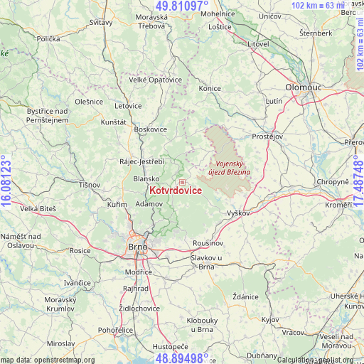
Kotvrdovice GPS coordinates[2]
49° 21' 18.396" North, 16° 47' 3.66" East
| Map corner | latitude | longitude |
|---|---|---|
| Upper-left | 49.81097°, | 16.08123° |
| Center: | 49.35511°, | 16.78435° |
| Lower-right: | 48.89498°, | 17.48748° |
| Map W x H: | 101.8×101.8 km | = 63.3×63.3mi |
| max Lat: | 51.01104° ⇑73.3% North |
| Kotvrdovice: | 49.35511° |
| min Lat: | ⇓26.7% South 48.60378° |
| min Long | Kotvrdovice | max Long |
| 12.17577° | 16.78435° | 18.82683° |
| W 71%⇐ | ⇒29% E |
Elevation
Elevation of Kotvrdovice is 535 m = 1755 ft, and this is 183 m = 600 ft above average elevation for this country.
| Max E: |
901 m = 2956 ft | 9.2% |
| Kotvrdovice | 535 m 1755 ft | |
| Avg. | 352 m = 1155 ft | |
Min E: |
136 m = 446 ft | 90.8% |
See also: Czech Republic elevation on elevation.city.
Geographical zone
Kotvrdovice is located in North temperate zone (between Tropic of Cancer and the Arctic Circle). Distance of this North polar circle is 1913.4 km =1188.9 mi to North.| Distance of | km | miles | from Kotvrdovice |
|---|---|---|---|
| North Pole | 4519.3 | 2808.2 | to North |
| Arctic Circle | 1913.4 | 1188.9 | to North |
| Tropic Cancer | 2881.9 | 1790.7 | to South |
| Equator | 5487.8 | 3410 | to South |


Nearby cities:
15 places around Kotvrdovice: (largest is in red/bold)
• Babice nad Svitavou
10.2 km =6.3 mi,  218°
218°
• Březina
8.6 km =5.3 mi,  197°
197°
• Jedovnice
2.4 km =1.5 mi,  240°
240°
• Křtiny
7.1 km =4.4 mi, 204°
• Lažánky
5.5 km =3.4 mi,  264°
264°
• Lipovec
3.6 km =2.2 mi,  25°
25°
• Olomučany
8.6 km =5.3 mi,  251°
251°
• Ostrov u Macochy
3.4 km =2.1 mi,  332°
332°
• Rozstání
6.2 km =3.9 mi,  40°
40°
• Rudice
4.7 km =2.9 mi, 244°
• Ruprechtov
5.7 km =3.5 mi,  121°
121°
• Senetářov
1.4 km =0.9 mi,  91°
91°
• Sloup
7.4 km =4.6 mi, 333°
• Vavřinec
7 km =4.3 mi,  318°
318°
• Šošůvka
6.6 km =4.1 mi,  339°
339°
Sources, notices
• [Note1] Compared only with cities in Czech Republic existing in our database
• [Src1] Map data: © OpenStreetMap contributors (CC-BY-SA)
• [Src2] Other city data from geonames.org with taken over terms of usage.
• [Src3] Geographical zone / Annual Mean Temperature by Robert A. Rohde @ Wikipedia
