Kamenice geodata
Kamenice (Vysočina) is a populated place; located in Czech Republic in Europe/Prague (GMT+2) time zone. With population of 1,760 people, there are 729 cities with bigger population in this country. Compared to other cities in Czech Republic, 72.7% of cities are located further ↑North; 51.3% of cities are located further ←West and 88.7% of cities have lower elevation than Kamenice. Note1


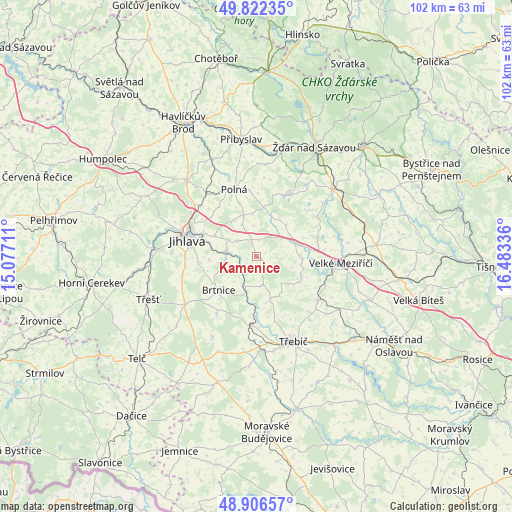
Kamenice GPS coordinates[2]
49° 21' 59.724" North, 15° 46' 48.828" East
| Map corner | latitude | longitude |
|---|---|---|
| Upper-left | 49.82235°, | 15.07711° |
| Center: | 49.36659°, | 15.78023° |
| Lower-right: | 48.90657°, | 16.48336° |
| Map W x H: | 101.8×101.8 km | = 63.3×63.3mi |
| max Lat: | 51.01104° ⇑72.7% North |
| Kamenice: | 49.36659° |
| min Lat: | ⇓27.3% South 48.60378° |
| min Long | Kamenice | max Long |
| 12.17577° | 15.78023° | 18.82683° |
| W 51.3%⇐ | ⇒48.7% E |
Elevation
Elevation of Kamenice is 521 m = 1709 ft, and this is 169 m = 554 ft above average elevation for this country.
| Max E: |
901 m = 2956 ft | 11.3% |
| Kamenice | 521 m 1709 ft | |
| Avg. | 352 m = 1155 ft | |
Min E: |
136 m = 446 ft | 88.7% |
See also: Czech Republic elevation on elevation.city.
Geographical zone
Kamenice is located in North temperate zone (between Tropic of Cancer and the Arctic Circle). Distance of this North polar circle is 1912.1 km =1188.1 mi to North.| Distance of | km | miles | from Kamenice |
|---|---|---|---|
| North Pole | 4518 | 2807.4 | to North |
| Arctic Circle | 1912.1 | 1188.1 | to North |
| Tropic Cancer | 2883.1 | 1791.5 | to South |
| Equator | 5489.1 | 3410.8 | to South |


Nearby cities:
15 places around Kamenice: (largest is in red/bold)
• Bohdalov
14.3 km =8.9 mi,  28°
28°
• Brtnice
10 km =6.2 mi,  228°
228°
• Jihlava
14.1 km =8.8 mi,  283°
283°
• Kněžice
13.2 km =8.2 mi,  216°
216°
• Luka nad Jihlavou
5.7 km =3.5 mi, 278°
• Malý Beranov
10.8 km =6.7 mi,  287°
287°
• Měřín
8.1 km =5 mi,  68°
68°
• Okříšky
13.5 km =8.4 mi,  183°
183°
• Oslavice
15.5 km =9.6 mi,  100°
100°
• Polná
14.1 km =8.8 mi,  341°
341°
• Puklice
9.4 km =5.8 mi,  266°
266°
• Přibyslavice
11.8 km =7.3 mi, 180°
• Rudíkov
14.9 km =9.3 mi,  126°
126°
• Stránecká Zhoř
10.8 km =6.7 mi,  82°
82°
• Velký Beranov
9.2 km =5.7 mi,  297°
297°
Sources, notices
• [Note1] Compared only with cities in Czech Republic existing in our database
• [Src1] Map data: © OpenStreetMap contributors (CC-BY-SA)
• [Src2] Other city data from geonames.org with taken over terms of usage.
• [Src3] Geographical zone / Annual Mean Temperature by Robert A. Rohde @ Wikipedia
